Storms, rain kick off the weekend in Ontario followed by an autumnal chill
This weekend will see a brief break in the spectacular late summer weather across Ontario. Rain, waterspouts, and chilly daytime highs are all on tap
After a week that brought abundant sunshine and warm September temperatures across much of Ontario, heavy rain and thunderstorms will kick off the weekend ahead. A strong cold front, supported by a potent upper level low, will help to bring in the soggy conditions to start.
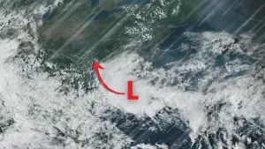
This is also the perfect setup for waterspout formation through the weekend, so it'll be important to remain alert to the changing conditions.
With the much cooler temperatures settling in, some northern regions could even see some wet snow with this active setup moving over Ontario.
Don't write off the summer season just yet, however, as pleasant late summer weather is expected to return possibly bringing some of the best conditions of the season we've seen so far.
MUST SEE: Chasing ‘the most elusive weather’: Whimsical waterspouts
Friday:
A strong cold front sweeping into southern Ontario Friday will trigger a risk for widespread rain showers and thunderstorms.
Above-seasonal temperatures sitting in the mid 20s will span the region ahead of the front’s arrival on Friday. But temperatures will soon plummet into the teens throughout the weekend.

September Outlook: Summer isn’t done with Canada just yet
The chance for showers will build across the Greater Toronto Area (GTA) through Friday morning. Through the afternoon, expect the chance for showers and thunderstorms to grow throughout the GTA, including Toronto, Hamilton, and the Niagara Peninsula.
Strong wind gusts and small hail will accompany the rain in areas that see storms. A widespread 10-20 mm of rain is expected across southern Ontario.

Heavier pockets of rain will develop through the late afternoon and into Friday night across the eastern end of the GTA and into cottage country and eastern Ontario. The heaviest rain continues to shift east out of the GTA.
Saturday:
We’ll start Saturday with the heaviest rainfall pushing into western sections of Quebec, with clouds and scattered showers over southern Ontario and the GTA. Most of the day in southern Ontario and the GTA looks to be dry.

Behind the front however, daytime high temperatures on Saturday will come in 5-10 degrees colder than they were at the same time on Friday, so you'll want to have some extra layers on standby.
Cold northwesterly winds combined with instability of the upper-level low will send wrap-around and lake-effect rain showers across Georgian Bay, Lake Huron, and parts of the GTA. Wind gusts of 30-50 km/h are possible throughout the region.

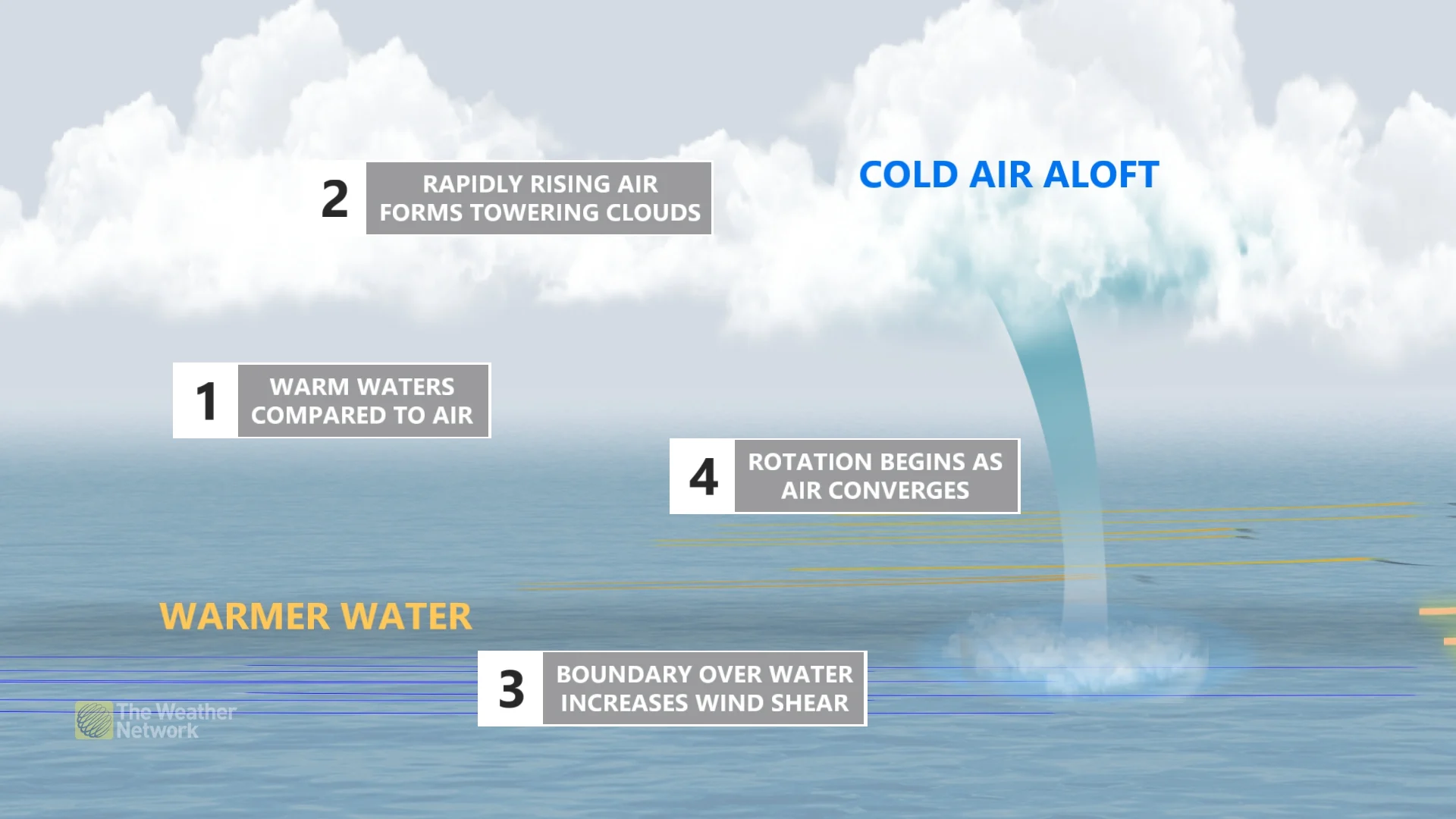
These cold northwesterly winds blowing over the relatively warm waters of the lakes will generate some instability below, with a good chance for waterspout development.
DON'T MISS: Ontario on waterspout watch this weekend
During the late summer and early fall are prime times to see waterspouts, as cooler air begins to settle in, but the lake temperatures are still quite warm. This creates a temperature gradient and instability between the air and lake surface, causing the air to rise rapidly, even outside of the presence of thunderstorms.
Waterspouts tend to be slow-moving or near stationary, but sometimes move onshore, where they can cause minor damage or injury. It is best to keep an eye on the weather warnings in your area, and adjust any outdoor plans accordingly.
WATCH BELOW: Why Ontario's gloomy weather comes with a waterspout risk
Sunday:
Clouds will build across the GTA once again on Sunday afternoon, with scattered showers expected through cottage country and a slight chance of some light rain in the GTA. High temperatures will remain in the teens.
FORECAST: Pleasant late summer weather is expected to continue through the end of next week
The periods of heavy rain and thunderstorms throughout the weekend will bring a risk of localized flooding in low-lying and flood-prone areas.
Don't write off summer just yet!
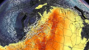
Temperatures will quickly rebound early next week as we head into an extended period of very warm and dry weather through the end of next week and next weekend, and possibly well into the following week. This could end up being the most extended stretch of warm and dry weather of the summer!
MUST SEE: A super typhoon may soon boost midsummer-like warmth in Canada
High temperatures will reach the mid to upper 20s and we could even see some 30°C days late next week and weekend. This pattern, and forecast confidence, is enhanced by what we are seeing in the western Pacific Ocean with a super typhoon, which is on a westward track to the south of China. This tends to enhance ridging in the jet stream pattern over eastern North American 8-10 days later.
Thumbnail image courtesy of Getty Images