Tropical Storm Helene forms, hurricane watches in effect for Florida
Tropical Storm Helene has formed and is forecast to rapidly intensify, possibly hitting Florida as a major hurricane on Thursday
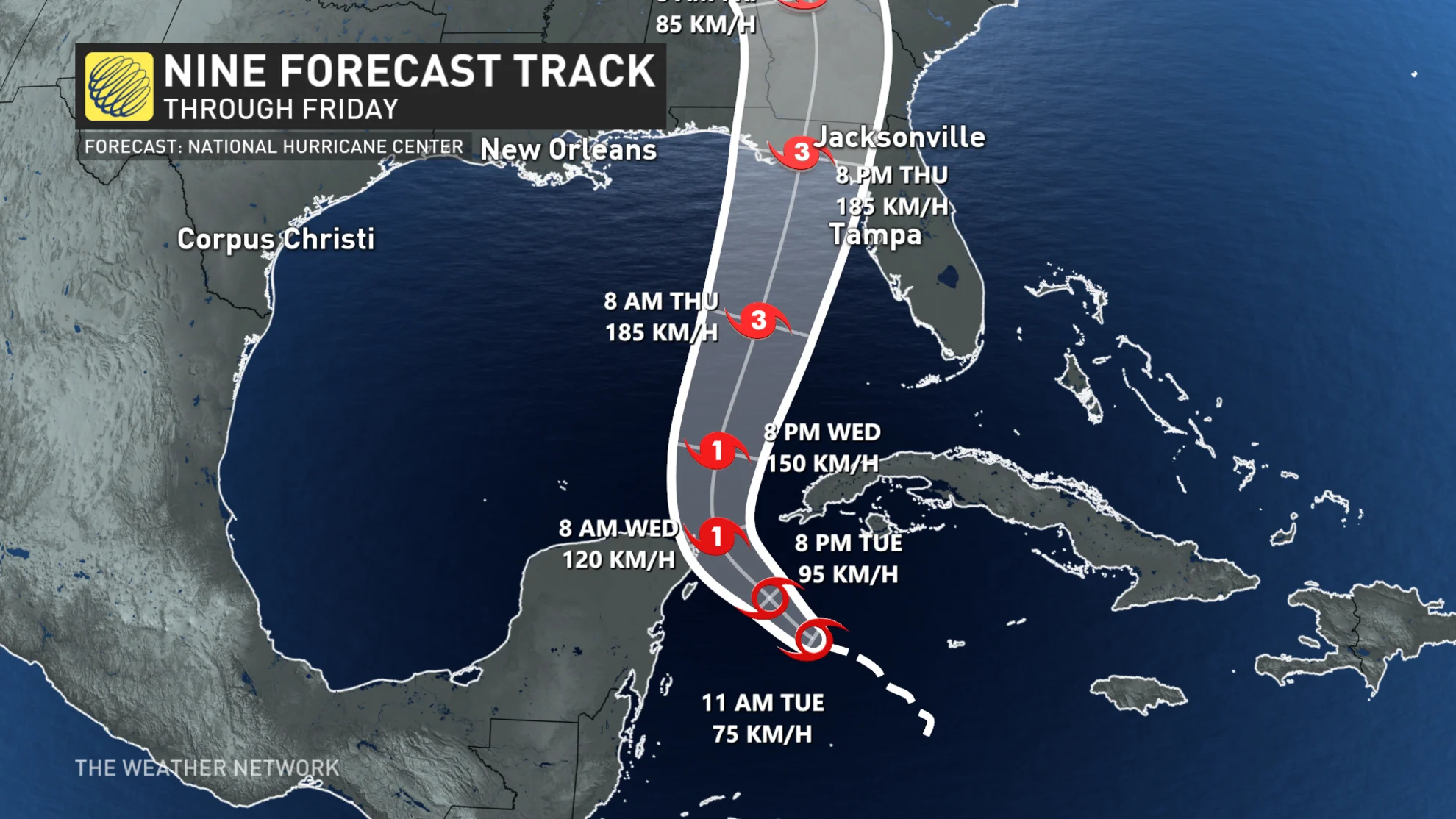
Tropical Storm Helene formed Thursday morning over the northwestern Caribbean Sea, sitting about 295 km southeast of Cozumel, Mexico, with maximum sustained winds of 75 km/h.
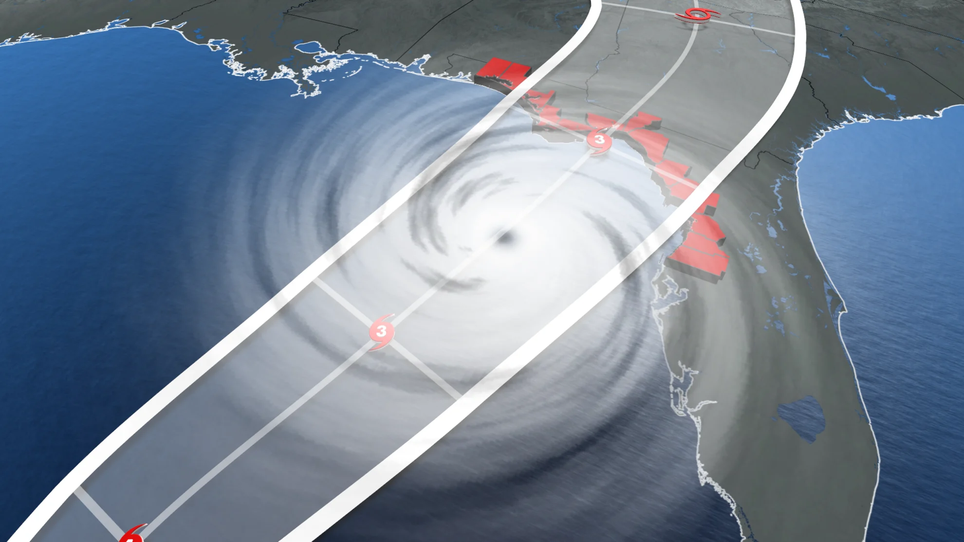
Helene is expected to rapidly intensify, with impacts to the Florida Panhandle likely as early as Thursday. A tropical storm warning has been issued for the Lower Florida Keys, as well as a storm surge watch for Tampa Bay. Hurricane watches remain place for parts of Mexico and Cuba.
DON’T MISS: La Niña could affect the second half of Atlantic hurricane season
"On the forecast track, the centre of Helene will move across the far northwestern Caribbean Sea through tonight, and then move across the eastern Gulf of Mexico Wednesday and Thursday, potentially reaching the Gulf coast of Florida late Thursday," said the U.S. National Hurricane Center (NHC) in Tuesday morning's update.
Helene to quickly become major hurricane by Thursday
Additional strengthening is forecast, with Helene expected to become a hurricane on Wednesday. By Thursday, Helene could strengthen to major hurricane status, the first of the year to make landfall. That will be just 48 hours of rapid intensification over the extremely warm waters of the Gulf of Mexico.
A spectacularly perfect track will curve the storm in between Mexico and Cuba. That will allow the storm to continue growing its eye, without disruption to land. The track also takes the storm over the loop current, which funnels in very warm water northward into the Gulf of Mexico where the warmest waters are.
MUST SEE: The Weather Network's hurricane hub for the latest updates on all tropical activity
Florida landfall looming
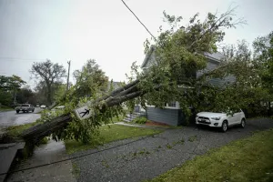
Landfall is expected along the Florida Panhandle, anywhere from Tampa to Tallahassee, Fla. Time is now running out for residents to make appropriate impact plans, which could include flooding rains, and potentially life-threatening storm surge.
There will be higher residential impacts if the track shifts east towards Tampa. Current trajectory to Florida’s Big Bend region is in a much lower population, so there should be a lower cost of damages depending on its track.
A state of emergency has been declared for 41 Florida counties, including Lee, Collier, and Charlotte counties, as the state braces for the potential impacts of Helene.
Regions of Southeast Florida are being urged to prepare as Helene's impacts will be exceptionally large and widespread. Significant power outages, and the threat of tornadoes will stretch far across the region.
"We already have nearly 18,000 linemen staged (and more en route), and are ready with search and rescue and roadway clearing crews," shared Florida Governor Ron DeSantis on X on Tuesday. "Stay tuned to local and state emergency recommendations and alerts. Get preparations in place now for the storm and heed evacuation directives, if issued, from local officials."
Residents of Florida's coastal areas will likely face evacuations on Tuesday.

(The Weather Network's Mark Robinson will be live on location in Florida as Helene makes landfall)
Total rain accumulations of 100 to 200 mm are forecast over western Cuba and the Cayman Islands, with isolated totals possibly reaching 300 mm. Over the eastern Yucatan Peninsula, 50 to 100 mm rain is expected with isolated totals over 150 mm.
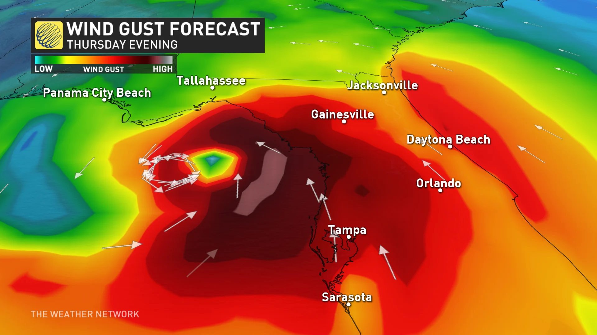
Over the Southeastern U.S., the storm is expected to produce total rain accumulations of 75 to 150 mm of rainfall, isolated totals of 250 mm, bringing a risk of flooding, of which some could be considerable.
"This rainfall will likely result in areas of considerable flash and urban flooding, with minor to moderate river flooding likely, and isolated major river flooding possible," the NHC warns.
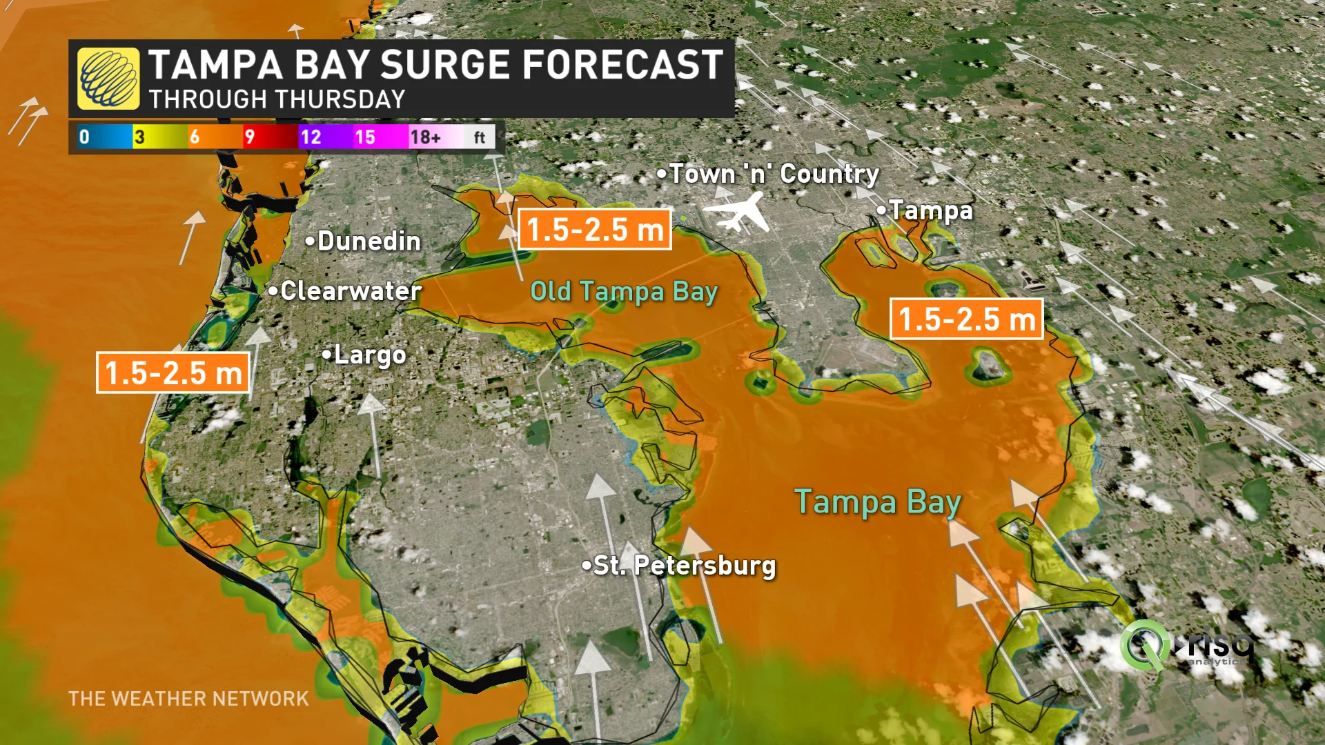
Storm surge forecast for Tampa Bay as of Tuesday afternoon
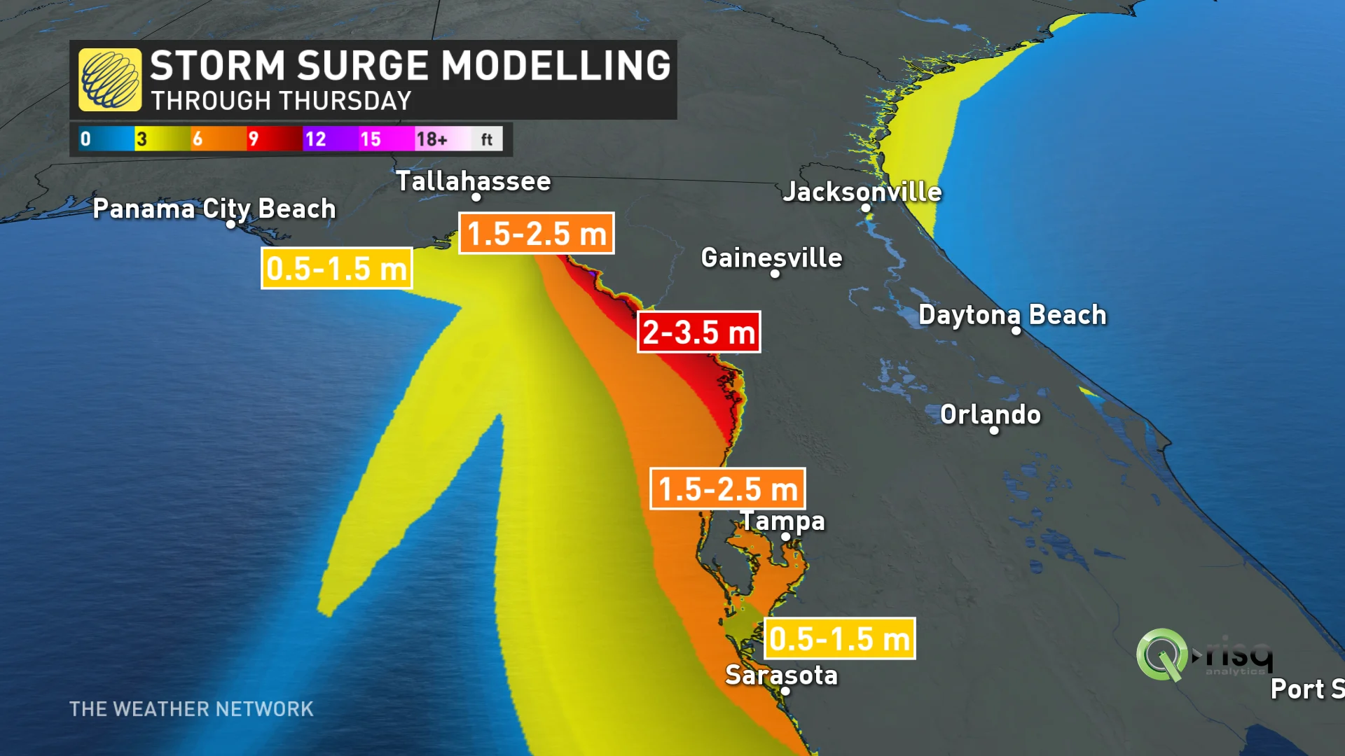
Dangerous storm surge, and strong winds are also expected for portions of the northeastern Gulf Coast, including the Florida Panhandle and sections of Florida's west coast.
"The combination of a dangerous storm surge and the tide will cause normally dry areas near the coast to be flooded by rising waters moving inland from the shoreline," says the NHC.
In places like Tampa Bay, storm surge could reach between 1.5-2.5 metres, while Florida's Ochlockonee River could see storm surge as high as 3-4.5 metres.
MUST SEE: Hurricane remnants can bring dangerous weather deep into Canada
The peak of hurricane season has passed, but no time to let our guard down, yet
The peak of hurricane season occurred on Sept. 10, but we're in the thick of the season through the middle of October, a period during which some of history’s most intense hurricanes have thrived and roared ashore.
It’s been an unusually and surprisingly quiet hurricane season across the Atlantic Ocean so far this year. Extremely warm sea surface temperatures and a budding La Niña led forecasters to expect a hyperactive season—the opposite has happened so far, with relatively few storms developing over the steamy ocean so far this year.
Despite the unexpected lull in activity this season, we could still see dangerous storms develop over the coming days and weeks. Coastal residents should closely monitor forecasts and have emergency preparedness kits ready to go long before a storm ever threatens land.