Atmospheric river wrings out across B.C., and a windier system is lurking next
The taps have been turned on, as parts of the B.C. coast continue to see heavy rainfall through Wednesday. The South Coast is next, and thunderstorms bring heavy rain and wind to the Interior
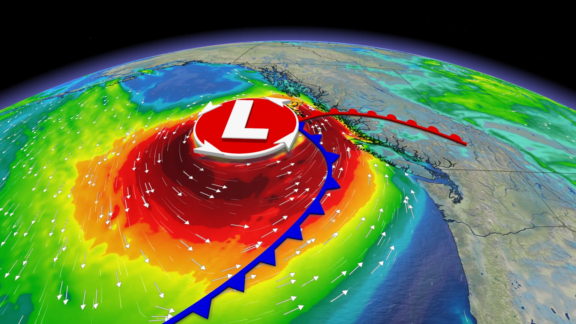
A powerful early-season atmospheric river has been targeting the north and central coast of British Columbia early this week, with the significant plume of moisture tracing all the way back to Southeast Asia.
Forecasts called for this potent early week system to be classified as a Category 5, the highest rating there is on the atmospheric river scale.
From Saturday until Monday places like Bella Bella have seen nearly 250 mm of rain already, with another 50-100 mm expected by Wednesday.
Visit our Complete Guide to Fall 2024 for an in depth look at the Fall Forecast, tips to plan for it and much more!
Areas that experience the heaviest rainfall this week could see landslides and power outages, as well as pooling and ponding of water on roadways.
Special weather statements now also line parts of the Interior, with a late season thunderstorm bringing the potential for very strong wind gusts and locally heavy downpours on Wednesday. It will be important to stay up-to-date on the latest warnings in your area.
Through Wednesday:
Moisture from southeastern Asia is the source region for this week's atmospheric river.
Atmospheric rivers are, for the most part, what you might imagine from the name — rivers of moisture in the sky. They’re long, narrow bands in the atmosphere that carry large amounts of water vapour, usually from the tropics where atmospheric moisture is abundant.

The atmospheric river will continue to bring heavy rain to the region through Tuesday, with another 50-100 mm on tap for some of the harder-hit areas. That's after 200+ mm has already fallen.
In regions of the heaviest rain, landslides and power outages are threats while pooling and ponding of water on roadways are possible, as well. Forest fire burn scars are sensitive to the risk for flooding, increasing the threat of soil failure and impacts.
WATCH BELOW: What is an atmospheric river?
SEE ALSO: Atmospheric Rivers: Expert explains the good and bad of these extreme storms
The atmospheric river will sink south Tuesday night, and eventually reach the South Coast overnight into Wednesday, with the risk for embedded thunderstorms to occur. The front will also move through the Interior and southeast B.C. on Wednesday, bringing thunderstorms and strong wind gusts between 60-80 km/h.

Thursday through Friday:
The stormy pattern continues into Thursday and Friday, as another system will track into the coast. Although less rain will be associated for the north and central coast, the late week system will certainly pack a punch in terms of winds.
This storm will feature a deeper area of low pressure, which is what will bring the wind gusts upwards to 100 km/h for the central and north coast, along with Haida Gwaii.

The winds will peak during the day on Thursday, with rain lingering into Friday.
Freezing levels will also drop, and the cooler temperatures in place could bring a fair amount of snow above 1500 m.

Overall, however, a drier-than-normal pattern will dominate for the South Coast region through the end of September and into the beginning of October, as well.