Flash floods 'imminent' after Chilcotin landslide: officials
The Tŝilhqot'in National Government (TNG) has declared a local state of emergency after a landslide blocked the Chilcotin River in British Columbia's Cariboo region.
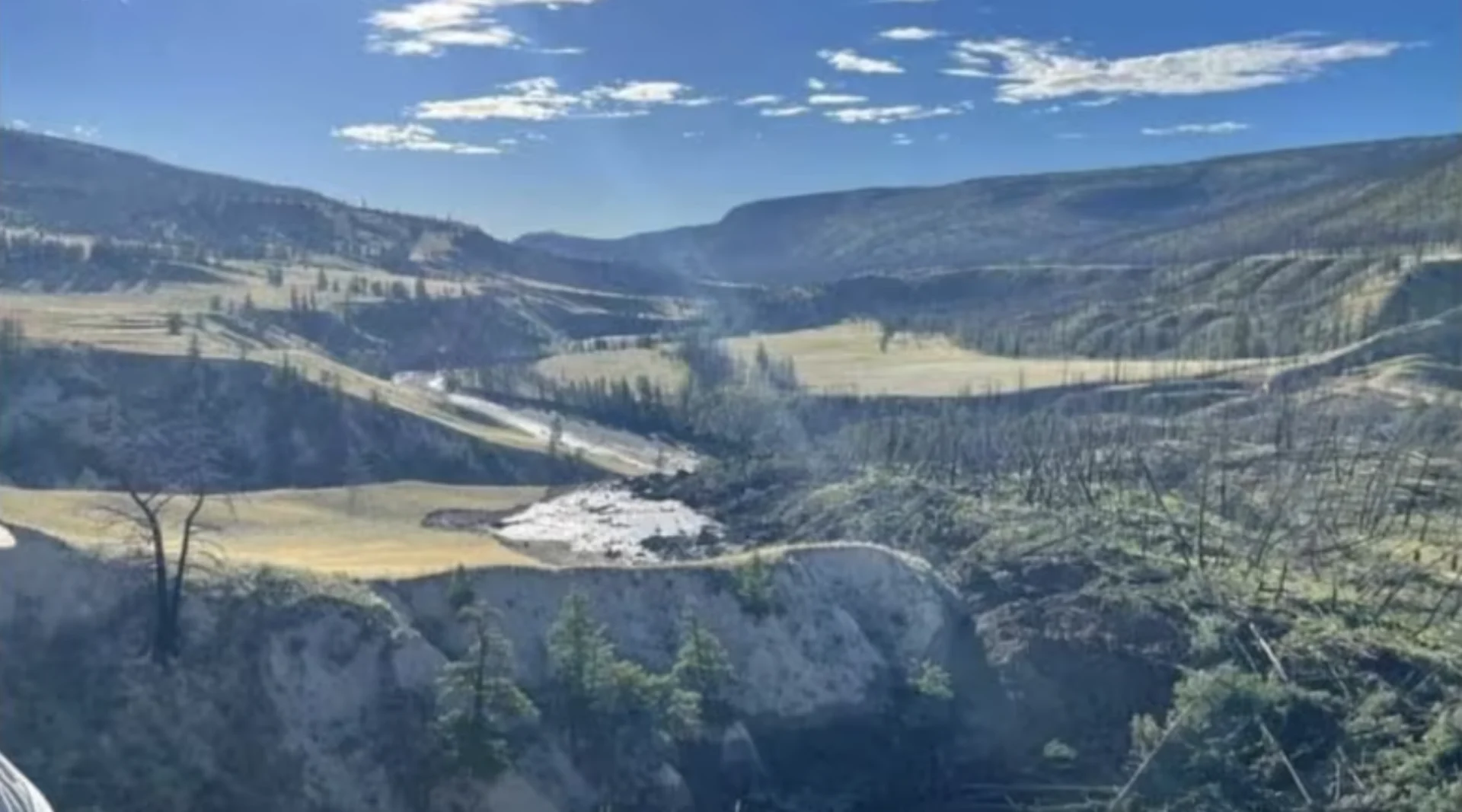
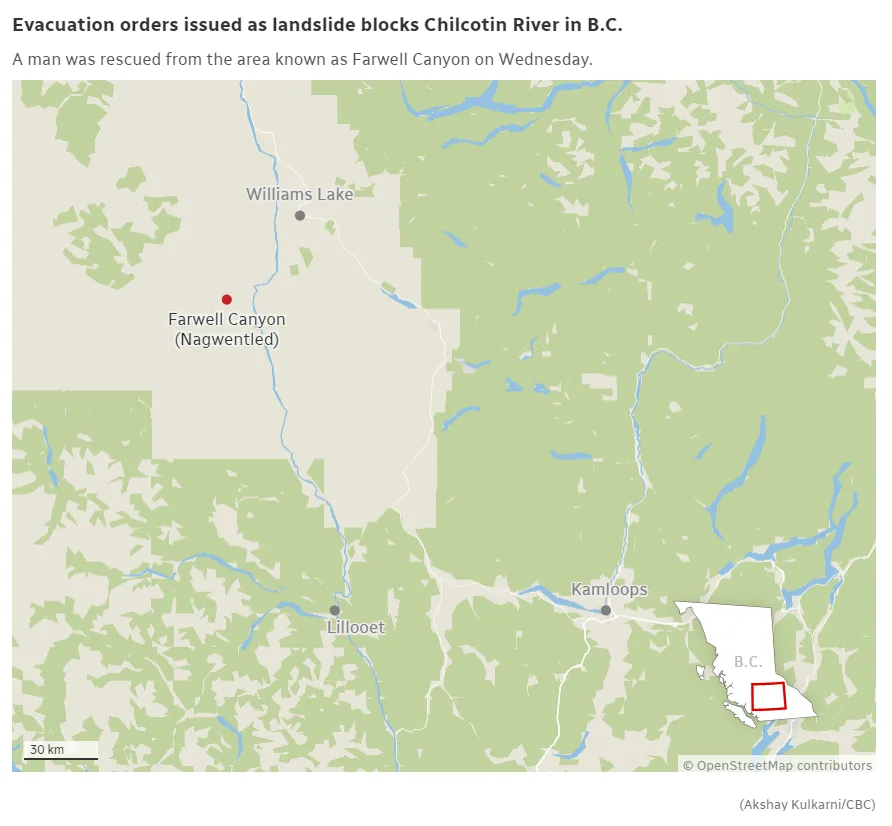
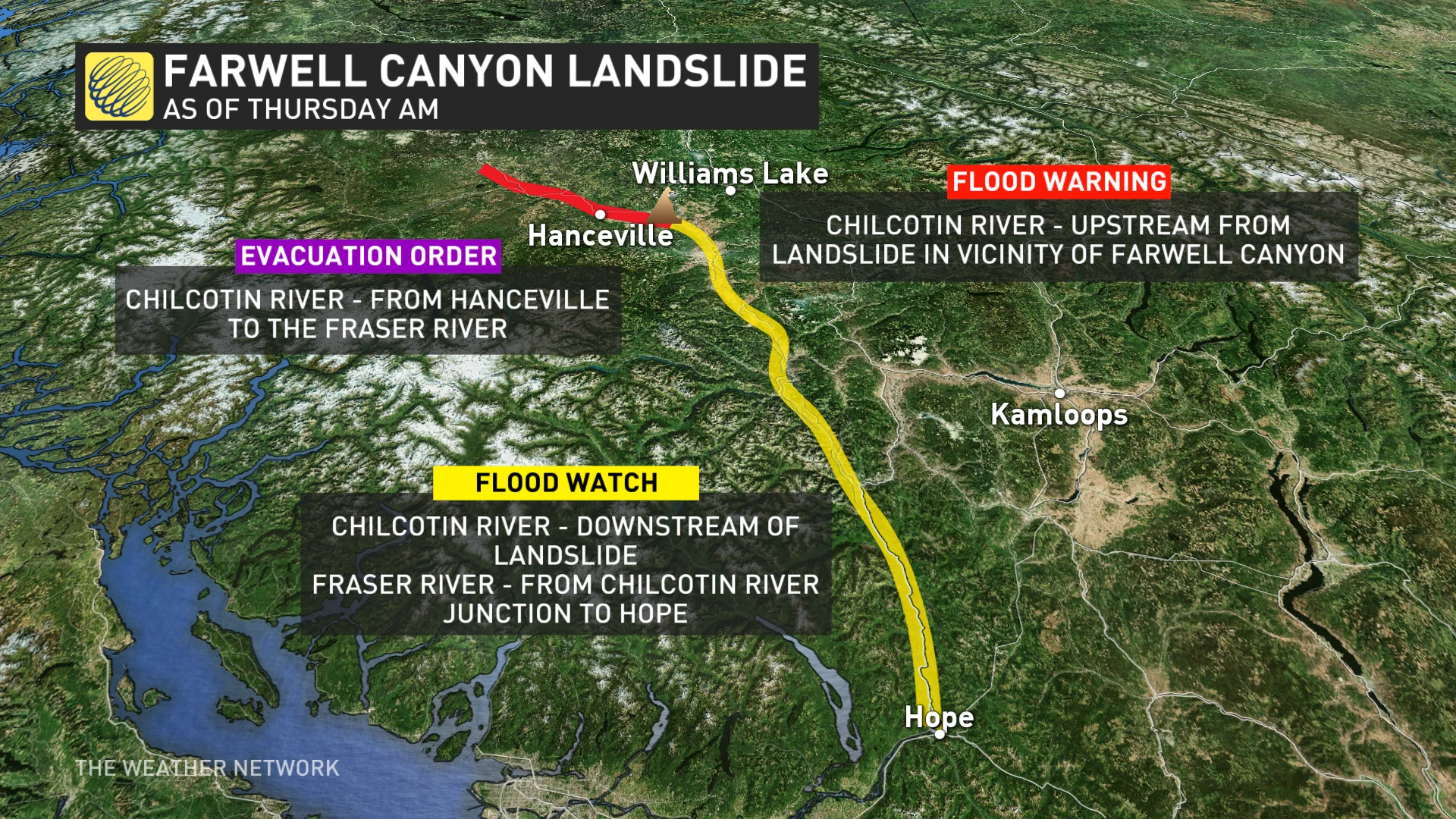
The announcement came Thursday afternoon following a slide of soil and debris upstream of Nagwentled, also known as Farwell Canyon, around 285 kilometres north of Vancouver. The TNG said the landslide is currently fully blocking the river.
Emergency officials said earlier in the day that flash floods are "imminent" and could happen within 24 or 48 hours.
"Flooding is building up above the dam created by the landslide, so it's like a lake," Cariboo Regional District chair Margo Wagner said at a virtual news conference Thursday.
"There is a high risk of a flash flood downstream if the river breaches that landslide — which it is expected to do eventually."
'People need to be prepared'
At a news conference Thursday, Nathan Cullen, the B.C. minister of water, land and resource stewardship, said the dam created by the landslide is 600 metres wide and 30 metres deep.
B.C. Emergency Preparedness and Climate Change Minister Bowinn Ma said on-site monitors show water is slowly leaking through the dam.
The B.C. River Forecast Centre issued a flood warning for the Chilcotin River upstream of the landslide. It's also issued a flood watch for the Fraser River, from where it meets the Chilcotin River downstream to Hope, B.C.

The Tŝilhqot'in National Government is asking people to stay away from the Chilcotin River due to unpredictable water behaviour following a landslide. (Deb Ilnicki / Facebook)
Ma asked residents to stay away from the banks of the Chilcotin River from Hanceville to the Fraser River and anywhere on or along the Fraser River from the Chilcotin River to Hope.
"If this dam were to break, it is possible that dozens of evacuation orders will be issued along both rivers, and people need to be prepared," Ma said.
Wagner told reporters water could either rise up over the landslide, or water could cause a fissure in the earthen barrier, causing it to give way.
"We don't know exactly when this landslide is going to give way," she said. "There would be a mass of water coming down."
She said many trees and debris from a wildfire in the region is also being held behind the landslide.
The Cariboo Regional District also issued two evacuation orders for a dozen homes, affecting 13 residents, due to "immediate risk of flooding."
The orders cover 60 parcels of land along the river, an area totalling about 106 square kilometres.
A map on the district's website shows the area stretches from the Big Creek Bridge, about 50 kilometres east to where the Chilcotin and Fraser rivers meet.
Evacuation orders recommend residents head north to Highway 20, then east into Williams Lake, B.C.
Province assessing damage
Cullen said that personnel are assessing the landslide on the ground, and crews are using remote sensing tools trying to create a map of the slide.
The B.C. Wildfire Service is using aircraft to help assess the situation and has dispatched several helicopters to assist with search and rescue in the area.
Ma said the province is prepared to take additional actions to keep people and communities safe in the event of flooding, such as deploying sandbags, sandbag machines, gabions and Tiger Dams.
Ma told reporters while evacuation orders do not affect many people at this time, an evacuation centre has been set up in Williams Lake.
She said while the province's primary concern is B.C. residents, flooding may also have significant effects on wildlife and river ecosystems.
Wagner said a forest fire in 2017 burned trees and a root system that was stabilizing the area, making it more vulnerable to landslides.
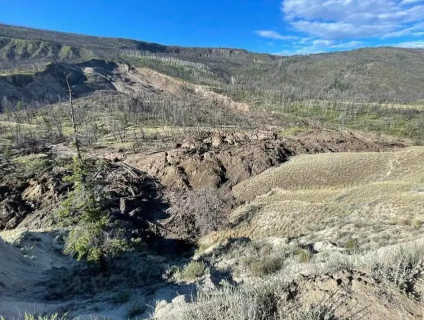
Debra Bortolussi, a spokesperson for Central Cariboo Search and Rescue, said the landslide is "very significant." (Submitted by Cariboo Regional District)
Man rescued
One man was rescued after being trapped by the slide.
In an email to CBC news Thursday, B.C. Emergency Health Services said the man was rescued and taken to the Wiliams Lake Airport by helicopter, and from there to hospital.
Paramedics said no other injuries linked to the landslide have been reported.
WATCH NOW: Landslides can happen anywhere in Canada and they're on the rise
This story was originally published for CBC News. With files from Tom Popyk.