Large, powerful Hurricane Milton makes landfall in Florida
The hurricane’s eye moved ashore near Sarasota, Florida, on Wednesday evening
Hurricane Milton made landfall near Sarasota, Florida, at 8:30 p.m. EDT on Wednesday as a Category 3 storm with maximum sustained winds of 205 km/h.
Forecasters with the U.S. National Weather Service (NWS) issued a rare "extreme wind warning" as the storm's intense eyewall approached the Tampa Bay area on Wednesday evening. "Treat these imminent extreme winds as if a tornado was approaching and move immediately to an interior room or shelter NOW!," the NWS said in its warning. A flash flood emergency was also in effect for the Tampa Bay area, including the cities of Tampa, St. Petersburg and Clearwater, with St. Petersburg already picking up more than 420 mm of rain on Wednesday.

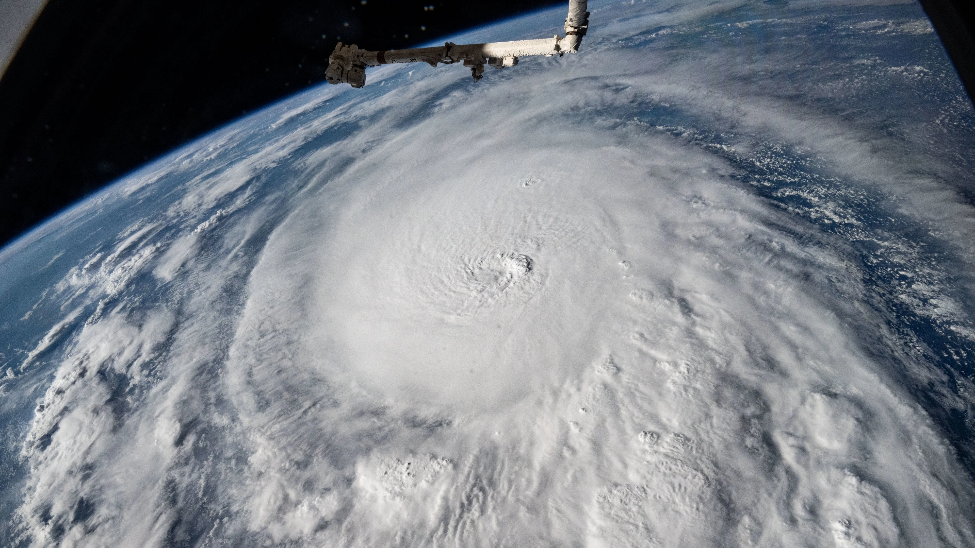
The large and powerful hurricane, which spent two days as a scale-topping Category 5 storm, was expected to push a life-threatening storm surge into the coast as it moved ashore.
As of Thursday morning, Milton was moving off the Florida east coast, but still producing damaging, hurricane-force winds and heavy rainfall. On the forecast track, the centre of Milton will move to the north of the Bahamas Thursday. Gradual weakening is expected, but Milton is forecast to become a powerful extratropical low Thursday night.
Keep up-to-date with the latest Hurricane Milton developments by visiting The Weather Network's hurricane hub.
There were more than 3.1 million customers without power across the state of Florida as of 5:30 a.m. EDT Thursday morning, according to data collected by PowerOutage.US. Power outages are expected to last for days in the storm's wake.
Winds gusted to 165 km/h at the Sarasota-Bradenton International Airport as the eye of the storm crossed the coast on Wednesday evening. A gust of 133 km/h was recorded at Tampa International Airport around 9:53 p.m. EDT.
Photos and videos posted to social media late Wednesday showed that the strong winds shredded the fabric roof off of Tropicana Field, which is home to MLB's Tampa Bay Rays. Another photo appeared to show a crane collapsed onto buildings in downtown St. Petersburg.
A Saildrone floating in the Gulf of Mexico near the centre of the storm on Wednesday evening reported waves of more than 8.5 metres high alongside hurricane force winds.
WATCH: Hurricane Milton eyewall moves over Florida during landfall
Life-threatening storm surge, wind damage ongoing
The storm surge warning remained in effect for the Florida west coast, from Bonita Beach northward to Middle of Longboat Key, including Charlotte Harbor, early Thursday morning. It also covered Sebastian Inlet Florida to Altamaha Sound Georgia, including the St. Johns River. The warning has been discontinued for Tampa Bay.
Florida's western coast is exceptionally vulnerable to storm surge flooding.
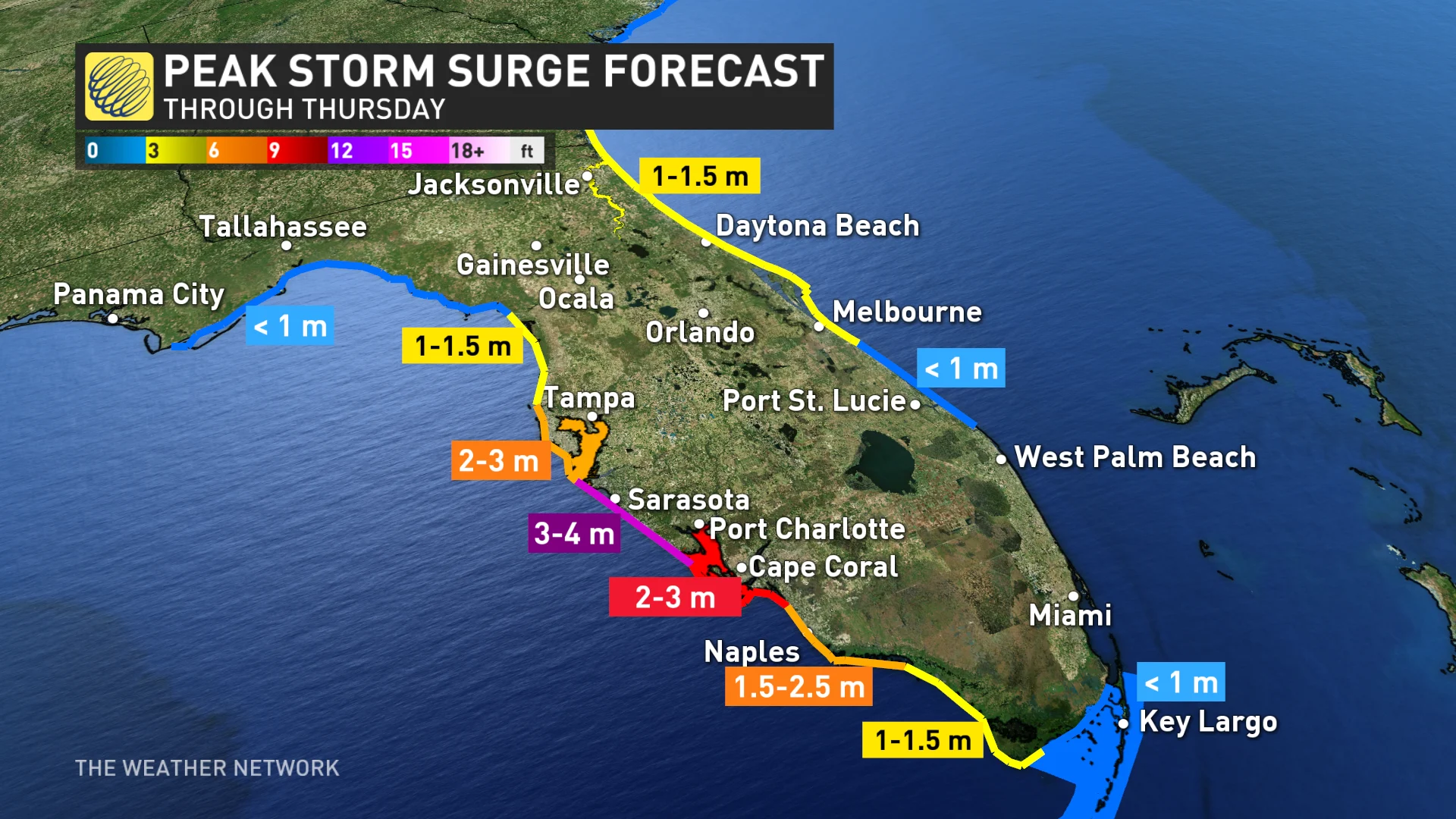
Communities near and south of the eyewall were expected to see up to 4.5 metres of storm surge flooding as the hurricane’s strong and persistent winds push seawater into the coast. This much inundation is unsurvivable for people in vulnerable areas.
More than one million people in coastal areas are under evacuation orders, with the region still reeling from the widespread destruction of Hurricane Helene just two weeks ago. Officials have called this the largest evacuation for the area since 2017 when Hurricane Irma hit, putting major strain on highways as residents flee, and leaving several gas stations without any fuel left.
Flooding rains, tornadoes also a major issue
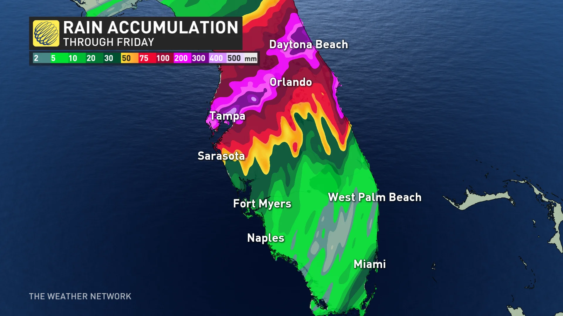
Many communities throughout Florida were forecast to see between 150-300+ mm of rain during this event. Some localized areas could even see up to 450 mm. By Wednesday night, St. Petersburg had already received 422 mm of rain. Additional rainfall amounts of 50-100 mm are expected across portions of the east-central to northeast Florida coast through Thursday.
"This rainfall will continue to bring the risk of considerable flash and urban flooding, along with moderate to major river flooding," said the U.S. National Hurricane Center (NHC) in its Thursday morning update.
We’ve also seen an intense and sustained tornado outbreak as Milton’s outer bands raked across the state of Florida.
At least 19 tornadoes were reported, causing damage in numerous counties and destroying around 125 homes. Storm chasers across southern and central Florida reported several large tornadoes during the day Wednesday.
Milton broke records before making landfall
Thanks to extremely warm sea surface temperatures, Milton quickly became one of the fastest, intensifying storms on record in the Atlantic Ocean, surging from a tropical depression to a dangerous Category 5 hurricane in just 49 hours.
It is also the strongest storm on our planet for 2024 so far, beating out Hurricane Beryl in July.
According to RBC analysts, Hurricane Milton could cost insurers up tp $100 billion.