How did Hurricane Helene get so destructive?
Hurricane Helene poured a devastating deluge on the southeastern U.S. this past week, killing at least 130 people by Tuesday, leaving hundreds missing, causing record flooding and storm surges and cutting power to millions of homes and businesses. Here's a look at just how bad it was — and a few reasons why.
Helene arrived as an "unusually large storm," according to the U.S. National Oceanic and Atmospheric Administration (NOAA), with violent winds extending up to 560 kilometres from its centre. It was also travelling twice as a fast as a typical Gulf of Mexico storm striking the coast.
RELATED: Thousands in North Carolina still without water after Helene's destruction
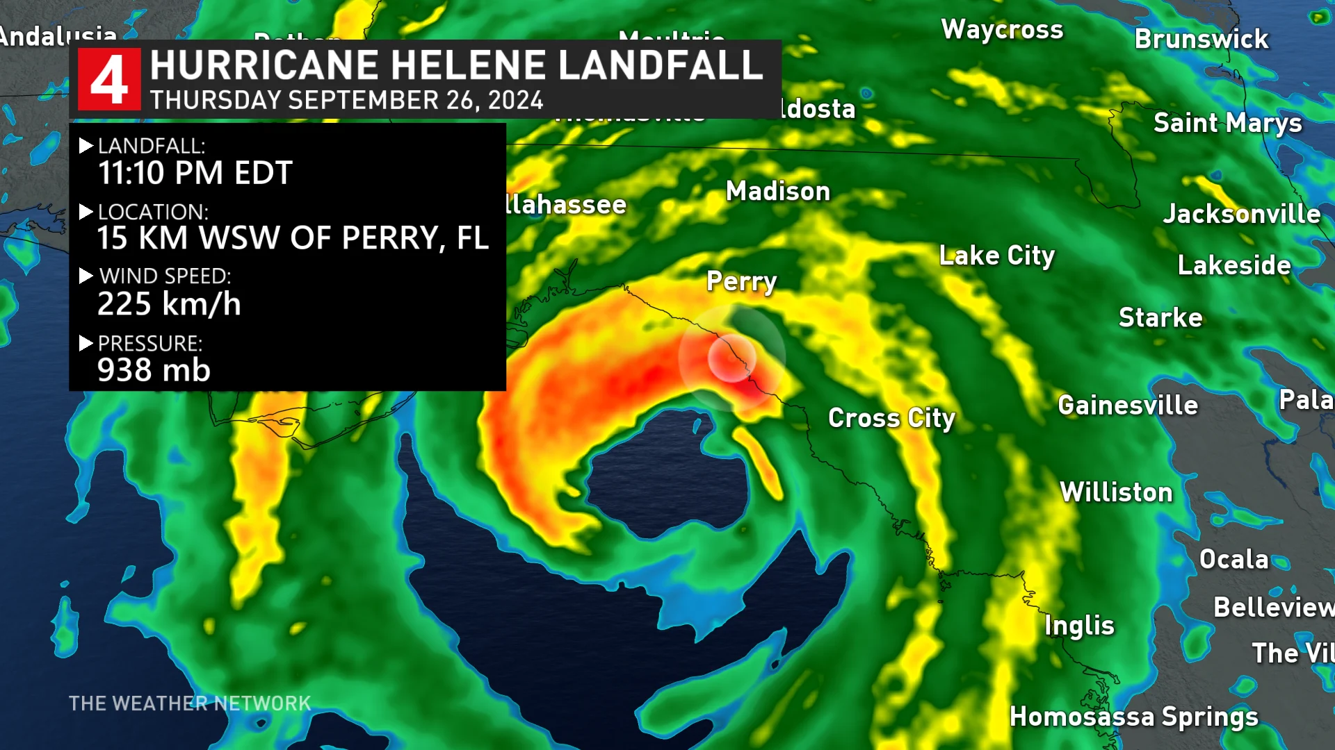
The storm made landfall in Perry, Fla., on Thursday night as a Category 4 hurricane, with winds reaching 225 km/h, according to NOAA, which said it was one of the most powerful ever to strike the U.S. On the Florida coast, it caused storm surges of up to 4.6 metres.
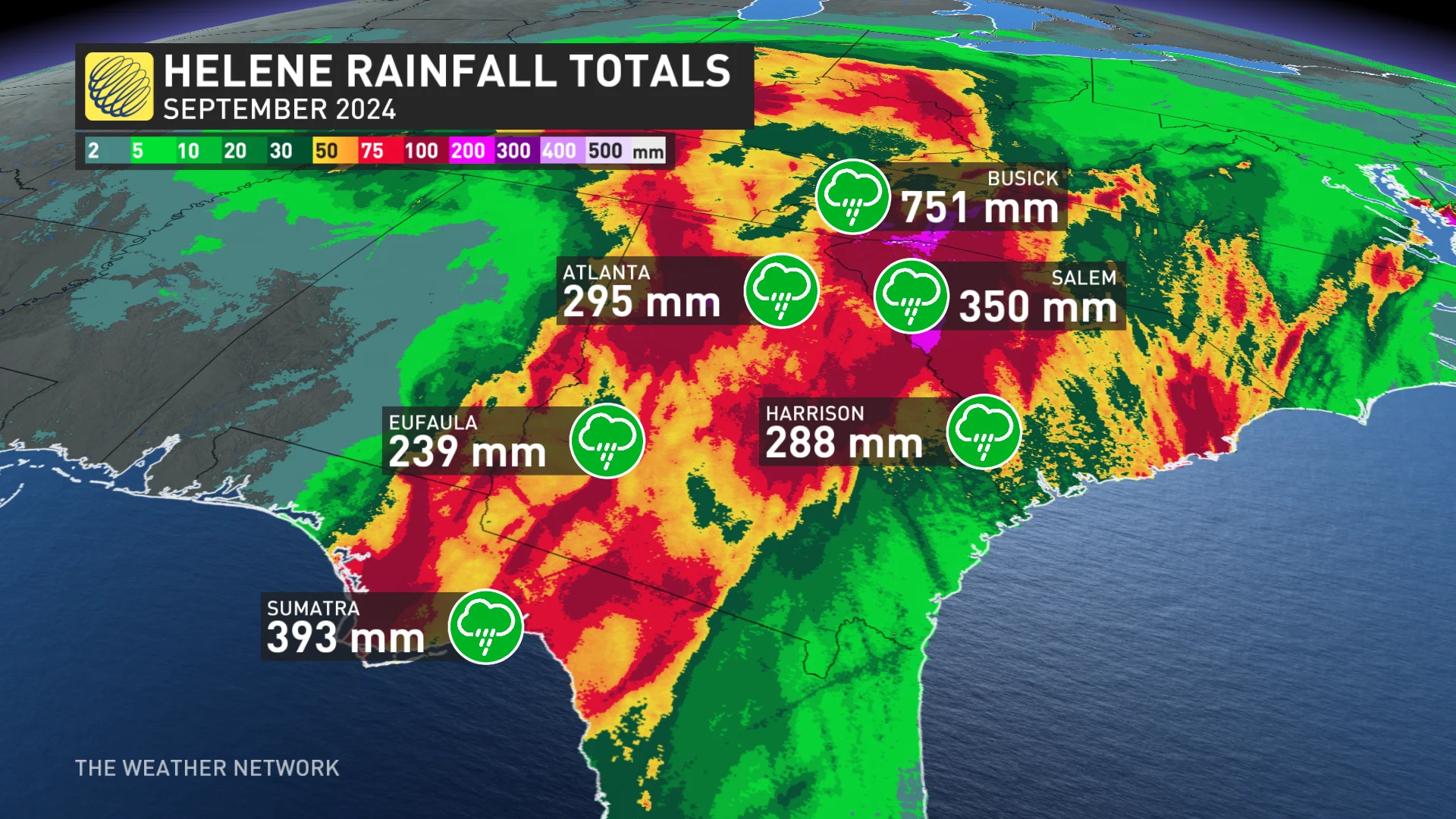
Meteorologist Ryan Maue and Ed Clark, head of NOAA's National Water Center, independently calculated that 151 trillion litres of water poured down on the southeastern U.S. over four days. That's enough to fill and overflow Lake Athabasca, Canada's 10th largest lake, or cover the entire surfaces of both Nova Scotia and New Brunswick together more than a metre deep.
The deluge caused record flooding in at least seven locations in North Carolina and Tenneesse, the BBC reported. In Buncombe County, N.C., where the town of Asheville suffered major damage, Ryan Cole, a local emergency services assistant director, described its impact as "biblical" devastation.
What made Helene so bad?
It came on the tail of other rainstorms
Many places hit by Helene, such as Asheville, N.C., had already been pounded by rain from other two or three other storms before the remnants of the hurricane arrived, including one that fell just short of named status along North Carolina's coast, said state climatologist Kathie Dello.
"Torrential rainfall from the remnants of Hurricane Helene capped off three days of extreme, unrelenting precipitation," said the North Carolina State Climate Office in a blog post Monday.
That meant streamflows were already at daily record highs and soils on local mountain slopes were already saturated by the time the remnants of Helene brought more heavy rain.
As Helene passed through, it could have mopped up some of the evaporating water as additional energy.
That's a phenomenon known as the "brown-ocean effect" since it resembles, on a smaller scale, the normal building of storms from ocean heat and evaporation.
Marshall Shepherd, director of the University of Georgia's atmospheric sciences program, told The New York Times that could have been a factor, and he and his colleagues are planning to study how much the effect could have contributed to Helene's force.
It hit the mountains
Helene was so fast and powerful that it moved far inland. Some of the areas most devastated by the storm were in the Appalachian Mountains of North Carolina, which saw "catastrophic flooding and unimaginable damage," the state's climate office said.
As storm clouds moved into the mountains, they were forced up and over. That "tends to squeeze out more rainfall," Doug Outlaw, a National Weather Service meteorologist told NBC News.
All that rainfall then rushes downhill.

(Mark Robinson/The Weather Network)
Climate change gave it fuel
Hurricanes are fuelled by warm ocean waters, and the heat has been "off the charts" in the Gulf, where Helene picked up steam after forming in the Caribbean Sea last Monday, reported Judson Jones, a meteorologist for The New York Times.
The storm strengthened very quickly — a phenomenon called rapid intensification. Helene had become a Category 1 hurricane by Thursday morning, and had intensified to Category 4 within 12 hours.
The ocean warming caused by climate change has generally led to hurricanes producing more rainfall, moving farther inland and undergoing rapid intensification more often.

Hurricane Helene satellite imagery from Sept. 26. (NOAA)
In the case of Helene, climate change caused it to drop 50 per cent more rainfall in some parts of Georgia and the Carolinas, and made those record rainfalls up to 20 times more likely, reported researchers at Lawrence Berkeley National Laboratory in a rapid climate attribution study released Monday. That study is based on methods used for a similar study on Hurricane Harvey, but has not yet been peer reviewed.
WATCH: Man and dog rescued from sea during Helene's peak
The story was originally written by Emily Chung and published for CBC News. It contains files from The Associated Press.