
Summer may be over, but the severe weather season hasn't fallen yet

Now that we're in the “-ber” months, it can be easy to forget that despite the colourful leaves, cooling temperatures, and shorter days, severe weather can still strike.
Spring in Canada is defined by its fickle and changeable patterns, giving us a taste of the summer to come one day and then taking us back in time to winter the next.
Heatwaves, wildfires, and thunderstorms steal the show in summer. Forecasters are kept busy monitoring for severe weather—watching closely for damaging storms, flooding, and tornado threats.
Once we hit fall, though, we begin to see a downward trend in thunderstorms. Cool, autumn air stabilizes the atmosphere, limiting thunderstorm development. But that doesn’t mean there is no more severe weather for the year—flooding rains and tropical remnants are still dangerous risks that stick around well into the season. For our neighbours to the south, tornadoes are also still a threat to watch out for into the fall months.
RELATED: What does a classic fall storm look like in your part of Canada?
Flooding can happen anywhere, any season
If there’s rain, there’s the risk of flooding. Especially in the fall season when the colourful leaves are falling from trees, coating everything below.
Gutters and storm drains can become easily clogged by leaves if left without being cleared for too long, raising the risk of basement flooding in people’s homes and flash flooding outdoors. Thunderstorms become much less of a threat in the fall months, but as the saying goes, “When it rains, it pours.”
Fall is a season known for its changeable weather patterns, flipping back and forth between days with summer-like heat and chilly days that make you want to stay bundled up inside.
However, it’s those changeable patterns that can result in fall storms packing a punch when they do happen. Fall storms in Canada will develop along the boundaries between the cooling continental air and the warm, humid air from the south. The stronger the temperature gradient is between the air masses, the stronger the storms and their development will be.

Heavy and prolonged downpours associated with strong storms can cause localized and flash flooding in communities.
It’s also important to keep in mind that tropical systems aren’t done as soon as summer ends.
Hurricane season lasts longer than you may think
When we think of destructive storms, we think of tornadoes and hurricanes. Tornado season starts in the spring and lasts through the summer, with some later/off-season exceptions.
The Atlantic hurricane season, however, starts in June and runs all the way through November. Some of the strongest hurricanes make landfall over the United States in the fall season, such as Hurricane Sandy in October 2012.
WATCH: StormHunter experiences the extreme winds of Hurricane Helene
When a hurricane makes landfall, it brings a deadly storm surge to coastal regions, along with flooding rains and damaging winds. Those on the outer bands of the storm don’t fare much better; while there is a much smaller risk of widespread storm surge, flash flooding from heavy rains is still a prominent danger and the hurricane’s rotating outer bands bring a heightened risk of tornadoes.
After a hurricane or tropical storm has made landfall and eventually died out, the tropical remnants can still make their way up into the northeastern States and parts of Eastern Canada. While not tropical storm-level, the remnants can still produce flooding rains.
Dixie Alley meets the Gulf stream for a ferocious pairing
Tornado season in the United States and Canada runs from late spring into early summer. The changeable transition from the cool spring to the hot summer helps to fuel instability and atmospheric energy, making it the perfect time for tornadoes to form.
SEE ALSO: Fantastic clouds, their significance, and where to find them
Outside of the traditional tornado season is when we’re likely to see the strongest and deadliest tornadoes form, specifically in a region known as Dixie Alley.
Dixie Alley spans across Georgia, Alabama, Louisiana, Arkansas, Mississippi, and Tennessee.
Warm, moist air from the Gulf stream collides with cool continental air over these states, creating a suitable atmosphere for storm and tornado development outside of the summer months.
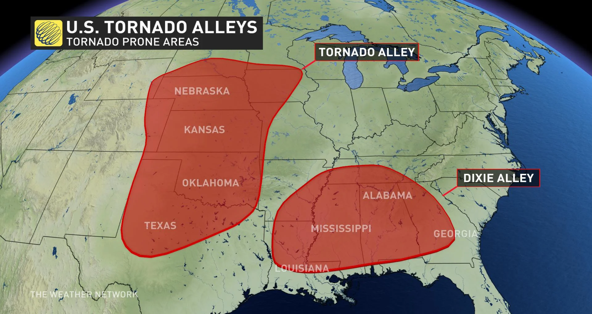
Thanks to climate change, we’re seeing record-high temperatures in the Gulf of Mexico, which fuels the Gulf stream later into the year than it used to. Because of this, we’re starting to see Dixie Alley become even more of an active hotspot for tornadoes throughout the year.
Researchers have also observed that the famous Tornado Alley is shifting eastward, eventually merging with Dixie Alley. What will likely happen is that we will see an increase in violent tornadoes in the coming years and a longer tornado season.
By late fall, our definition of severe weather may begin to shift towards snowstorms as the temperatures decrease and winter weather starts to move in.
Written with files from Tyler Hamilton, a meteorologist at The Weather Network.