Prairies: After record-setting warmth, temperatures plunge
Some communities saw a few temperature records broken for February 1st, but a return to reality beckons for the second half of the weekend.
What goes up, must come down. The western Prairies experienced well-above seasonal temperatures Saturday as Chinook winds howled down from the mountains, but a return to more seasonal temperatures looks for Sunday. Beyond, a more typical winter pattern will lock in during the first week and half of February. A look ahead, below.
WEATHER HIGHLIGHTS
After record warmth Saturday, temperatures nose dive Sunday
Snow lingers for northern regions into Sunday, while winds diminish
Wind chills return Monday overnight, wintry weather pattern locks in during first week of February
Keep on top of alerts in your area
WEEKEND: SNOW, SHARP RISE AND FALL IN TEMPERATURES
Saturday was marked in the western Prairies by a chinook wind event that brought gusts exceeding 100 km/h in some areas, and significantly high elsewhere, that also sent temperatures soaring well above seasonal in short order -- the city of Calgary, for example, saw temperatures go from -3°C to 11°C in a 30-minute period.
By Sunday, however, those winds will ease and temperatures will take a significant dive and could drop by as much as 13 degrees in Medicine Hat and 12 degrees in Regina, where temperatures will be hovering at or below the freezing mark. Edmonton, Calgary, Lethbridge and Saskatoon will see a 8-10-degree dive.
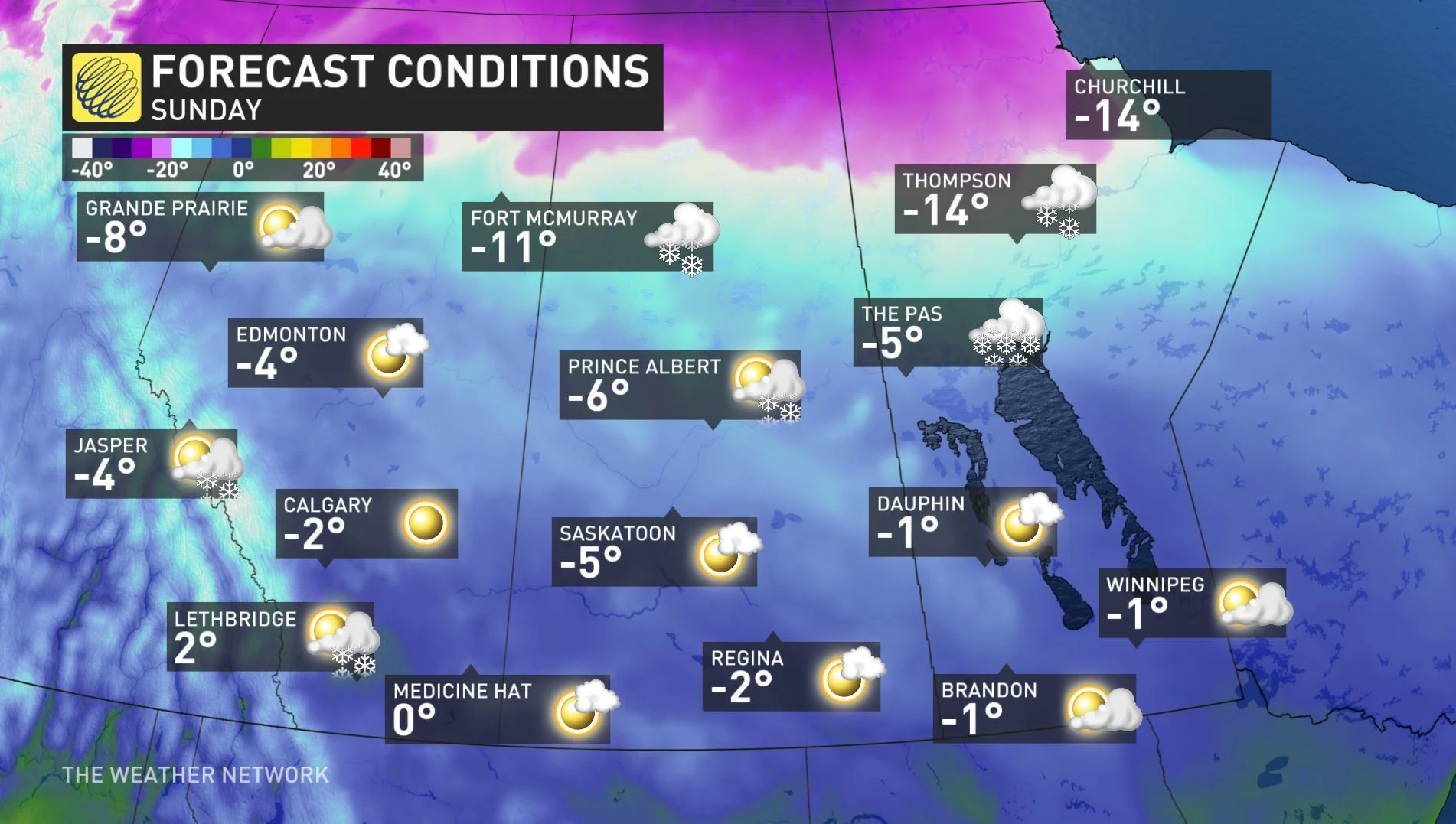
Precipitation-wise, a system moving through the region spread snow across much of the northern areas of Saskatchewan and Alberta Saturday night, reaching down into Manitoba's interlake region and somewhat into central Alberta as well.
By the time it tapers on Sunday, areas in northern Alberta and Saskatchewan may get 10-15 cm, while pockets of central portions in both provinces, as well as Manitoba, could get 5-10 cm in the same time period.

Another trough will quickly move through southern Alberta Sunday afternoon and evening but will move out Monday morning.
NEXT WEEK: THE WICKED WIND CHILL RETURNS
A more widespread and typical winter pattern looks to lock in during the first week of February (and first half of the month) across much of the Prairies, with wind chill values plummeting well into the -20s for Monday overnight.


