
October records could fall in Ontario as thermometer continues to climb
All-time October heat records are in jeopardy across several Ontario communities this week as the atypical warmth continues, potentially even surpassing daytime highs in the U.S. Southwest
Many communities across Ontario could see their warmest October days ever recorded this week as a large ridge of high pressure builds in the atmosphere high over the Great Lakes region.
On Tuesday, southern Ontario will be basking in the high 20s, approaching the 30-degree mark. There is a reasonable chance a couple communities will achieve it, a daytime high that's usually reserved for July, not October.

Some models even indicate that Pearson, Buttonville, Tottenham, Ottawa and Pembroke airports could hit 30°C, with eastern Ontario getting close on Wednesday, as well.
If Ottawa hits 30°C Tuesday or Wednesday, it would become the latest 30°C reading in city history. The previous latest was Sept. 27, 2017.
Visit our Complete Guide to Fall 2023 for an in-depth look at the Fall Forecast, tips to plan for it and much more!
On Monday, Las Vegas topped out at 23°C, with Toronto more than 4°C warmer. Sunday featured a temperature of 24°C as a daytime high, with Toronto soaring to 26.9°C.
Pearson International Airport recorded a reading of 27.3°C on Oct. 2, warmer than 26 days in the month of August. If the airport hits 29.6°C on Tuesday, it will be warmer than any day in the month of August this year.

This flashback to summer in the heart of fall will build over Ontario courtesy of an atmospheric blocking pattern known as an Omega block.
Named for its resemblance to the Greek letter, Omega, this kind of blocking pattern sees a ridge of high pressure bookended by troughs on either side, essentially locking the ridge in place for days on end.
SEE ALSO: How a giant blockade over Canada will shatter October heat records
A pattern like this during the true heart of summer would bring a terribly dangerous stretch of excessive heat, but the idea of "seasonable" changes quickly this time of year.
Temperatures 10-15+ degrees above seasonal at the beginning of October just means short-sleeves instead of sweaters.

DON'T MISS: October attempts to defy El Niño in Canada with atypical fall warmth
As a result of this stubborn pattern, we’re going to see a very long stretch of abnormally warm conditions bathe Ontario for most of the first week of October.

RELATED: From upper 20s to snow: Huge pattern flip looms for Central Canada
Moosonee could break its all-time October temperature record. Its current monthly record is a 27.7°C reading set in October 2011. The community’s predicted high on Oct. 4 is 28°C.
It’s not just daytime highs that’ll come in warmer than usual. Warm days will bleed into warm nights, especially across southern Ontario, where some spots are on the lookout for their warmest minimum temperatures ever recorded during the month of October.
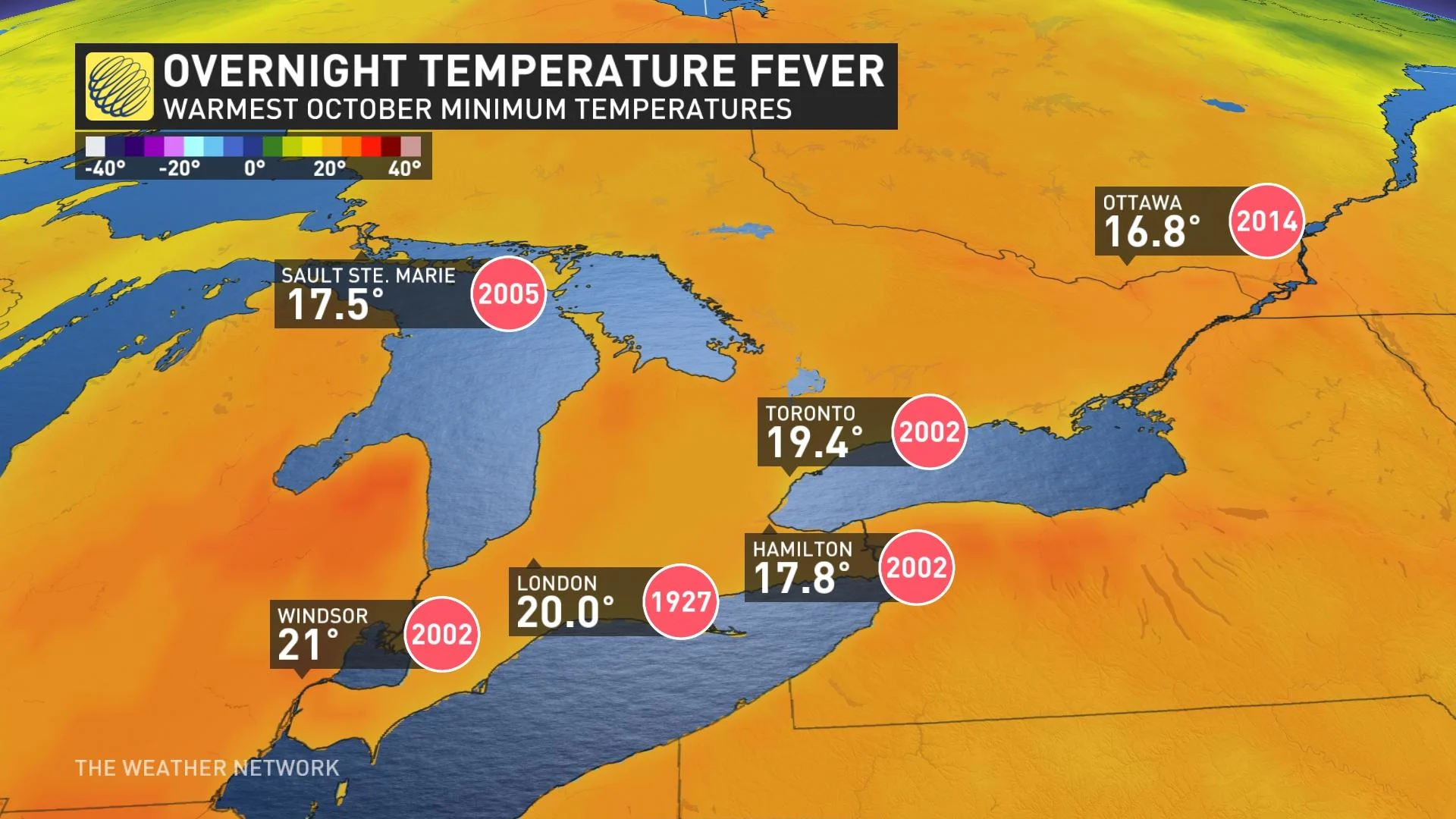
Toronto’s low temperature on Wednesday could bottom-out at an even 20 degrees, which would become the city’s warmest October low, beating a 19.4°C morning recorded back in October 2002.
Some sense of normalcy will eventually return, of course, and the warmth is on borrowed time. We’re likely to see a major pattern flip toward more seasonable conditions by the end of the week or next weekend.
Find out what the rest of October has to offer in our October outlook.