Major Hurricane Helene nears Florida with 'catastrophic' winds, storm surge
Hurricane Helene could bring catastrophic winds and life-threatening storm surge, with officials warning to heed evacuation orders as this is not a survivable event for those in coastal or low-lying areas
Helene is now a dangerous major hurricane as it continues to intensify in the eastern Gulf of Mexico. The storm is on a fast track toward landfall on the Florida Panhandle on Thursday evening.
"Preparations to protect life and property should be rushed to completion," warned the U.S. National Hurricane Center (NHC) in its Thursday morning update, adding that 'catastrophic' winds and storm surge would impact the Northeastern Gulf Coast.
As of Thursday evening, Helene swirled about 145 km south of Tallahassee, Fla., with maximum sustained wind gusts of 225 km/h, bumping it to Category 4 intensity.
DON’T MISS: Closely watching as Helene moves, but here's why Canada will likely be spared
Hurricane and tropical storm warnings have been issued, as well as a storm surge warning for Tampa Bay and Charlotte Harbor. Residents were urged to heed any evacuation orders as storm surge could rise to life-threatening heights of 6 metres in the Big Bend area of Florida's Panhandle. Dangerous flooding and powerful winds are expected to extend into Georgia and the Carolinas, as well.

According to the NHC, a significant increase in forward speed is forecast over the next 24 hours, bringing the centre of Helene across the eastern Gulf of Mexico and to the Florida Big Bend coast by Thursday evening or early Friday morning.
"After landfall, Helene is expected to turn northwestward and slow down over the Tennessee Valley on Friday and Saturday," the NHC says.
MUST SEE: The Weather Network's hurricane hub for the latest updates on all tropical activity
Helene barrels towards Florida, Thursday landfall looming
Landfall is expected along the Florida Panhandle, anywhere from Tampa to Tallahassee, Fla. around 8 p.m. local time on Thursday.
According to John Dailey, the mayor of Tallahassee, this could be the strongest storm to ever make a direct hit on the city. Helene could produce "unprecedented damage like nothing we have ever experienced before as a community," Dailey said in a news conference on Wednesday.
RELATED: Hurricane Helene will halt flights causing a domino effect of delays
Thousands have already evacuated along Florida's Gulf Coast, including Sarasota and Charlotte counties, and time is now running out for residents to make appropriate plans for impact. Officials warn that this is not a survivable event for those in coastal or low- lying areas. The threat for flooding rains, damaging winds, and potentially life-threatening storm surge are all on the table. Power outages will likely be counted in the millions of customers.
A state of emergency has been declared for 61 of Florida’s 67 counties. The storm will span beyond Florida, as well, as much of the Southeast prepares for Helene's exceptionally large and widespread impacts..
"Do not get wedded to the "cone," as hazards such as tornados, flooding, and storm surge can create dangerous conditions far beyond the cone," said Florida Gov. Ron DeSantis on X.
Earlier this week DeSantis shared that there were nearly 18,000 linemen staged, with more on route, ready with search and rescue, and roadway clearing crews.

(The Weather Network's Mark Robinson will be live on location in Florida as Helene makes landfall)
Life-threatening storm surge
Dangerous storm surge, and strong winds are expected for portions of the Northeastern Gulf Coast, including the Florida Panhandle and sections of Florida's west coast.

"The combination of a dangerous storm surge and the tide will cause normally dry areas near the coast to be flooded by rising waters moving inland from the shoreline," says the NHC.
In places like Tampa Bay, where special attention needs to be paid, storm surge could reach between 1.5-2.5 metres, which will cause significant damage if peak heights come to fruition. Florida's Ochlockonee River could see storm surge as high as 4-5.5 metres, and some isolated areas could even see storm surge up to six metres high.

This is an extreme storm surge forecast, and similar to Hurricane Laura's surge in Louisiana in 2020. U.S. record-breaking storm surge remains Hurricane Katrina with 8.53 metres (28 feet) across southern Mississippi.
Threat for considerable flash flooding with torrential rains
Total rain accumulations of 100 to 200 mm are forecast over western Cuba and the Cayman Islands, with isolated totals possibly reaching 300 mm. Over the eastern Yucatan Peninsula, 100 to 150 mm rain is expected with isolated totals over 200 mm.
Over the Southeastern U.S., the storm is expected to produce total rain accumulations of 100 to 200 mm of rainfall, and isolated totals of 300 mm. This brings a risk of flooding, some of which could be considerable.

"This rainfall will likely result in catastrophic and potentially life-threatening flash and urban flooding, along with significant river flooding. Numerous landslides are expected in steep terrain across the southern Appalachians," the NHC warns.
Tennessee's all-time rainfall record from the tropics is in jeopardy, and currently stands at 345 mm with Tropical Storm Chris in 1982.
MUST SEE: Hurricane remnants can bring dangerous weather deep into Canada.
WATCH: Rains begin in Florida as Hurricane Helene advances in the Gulf
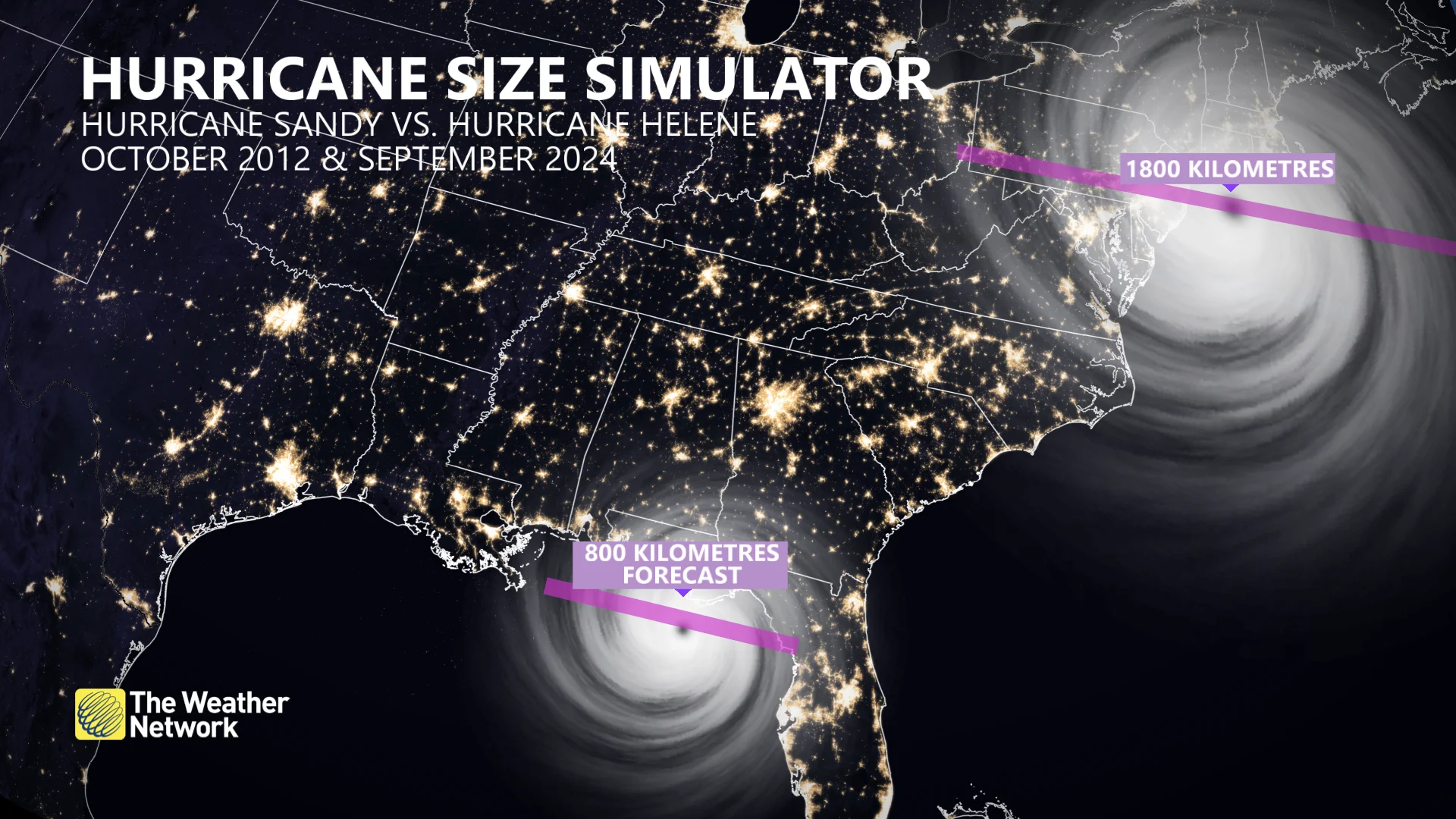
All computer models highlight Hurricane Helene will be well above average in terms of storm diameter, extending to more than 800 km across. It’ll take up roughly half the size of the Gulf of Mexico, with impacts spreading in some cases to as much as 500 km from the eye.
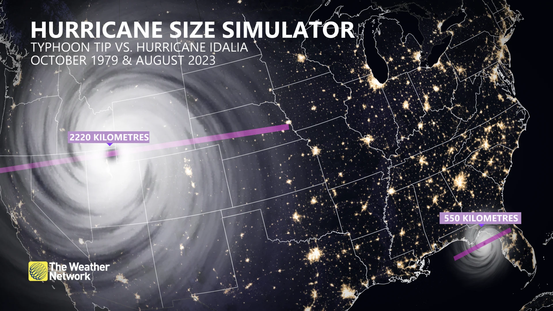
The largest hurricane diameter in history was Typhoon Tip in 1979, having a span exceeding 2,000 kilometres.
Helene is forecast to be about 60 per cent larger than Hurricane Idalia, which caused $3.6 billion worth of damage. Even though Helene is forecast to have a diameter close to 800 kilometres, it’s half of what Hurricane Sandy’s width was in October 2012.
Despite the unexpected lull in activity this hurricane season, remember that we could still see dangerous storms develop over the coming days and weeks. Coastal residents should closely monitor forecasts and have emergency preparedness kits ready to go long before a storm ever threatens land.
WATCH: How two decades of science has shrunk the hurricane cone
With files from Reuters