High Level fire caught blowing 'smoke rings', see why
Sunrise caught the Chuckegg Creek Fire blowing smoke rings on Wednesday.
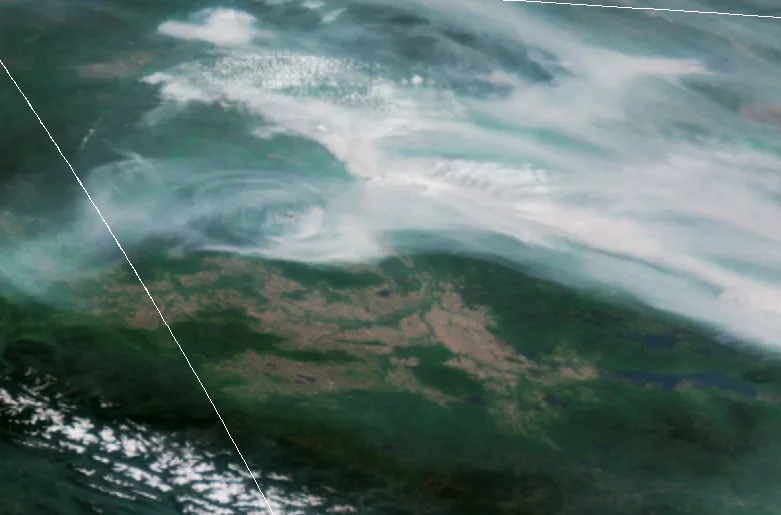
Visible satellite captured these strange smoke formations just after sunup, showing both the fire's surge to the northwest and a bizarre series of smoke rings centred near the fire's main plume.
The images caught the eye of Weather Network meteorologists, who spent some time reconstructing what was likely behind the phenomenon, and it seems to be a mix of fire behaviour and how the atmosphere changes overnight and after sunrise.
Summer revealed! Visit our Complete Guide to Summer 2019 for an in depth look at the Summer Forecast, tips to plan for it and much more

THE OVERNIGHT SETUP
During the overnight hours, a cooler pool of air tends to form close to the Earth's surface. That's because the ground cools faster than the air above it (as it radiated infrared energy), and it leeches warmth out of the air above it. This process sets up what's known as an inversion, where a layer of milder air lies atop a cooler layer and puts a 'lid' on the stable, lowest level of the atmosphere.
In the case of the fire, however, it's a bit different.
"I'm thinking the layer closest to the ground is more turblent because the fire is a separate, intense heat source," says Weather Network meteorologist and science writer Scott Sutherland. "So instead of having a calm layer closest to the ground, you have one that's more active. In that kind of setup, you might see some looping behaviour from the smoke plume."
SMOKE RINGS AT SUNRISE
That term "looping" refers to one of the ways a plume of smoke can act once it leaves its source (usually modelled as a smokestack, but in this case, the fire).
Essentially, the smoke plume begins to rise as you'd normally expect from the fire, only to bump into the lid supplied by the inversion layer, and then sink again. That process repeats when the warm, smoky air rises once again.
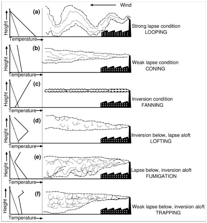
Different kinds of smoke plumes. The one we're interested in here is at the top. *Image: Dash, Prasanjit. (2015). METEOROLOGICAL PROCESSES IN THE BOUNDARY LAYER AND THEIR IMPLICATIONS ON THE SURFACE TEMPERATURE – THE BASICS. 10.13140/RG.2.1.2929.3282. *
In this case, as seen from above, the looping action looks to be radiating out from the centre, with each time the plume bumps into the inversion layer appearing as another ring.
MORNING SUNSHINE PUTS AN END TO THE SHOW
Sunup is the beginning of the end for this strange effect, as the sun's rays start to warm up that cool layer of air and lift the lid back off the lower atmosphere. You can see this happening on the satellite image when the ring start to erode and the smoke plume gets caught up in the overall flow from the northwest.
WHAT'S WITH THAT SURGE?
Just after dawn, the satellite shows a strong surge to the northwest. It's hard to know the exact cause of this event -- it might be related to fire control efforts overnight -- but the Alberta Wildfire update on Wednesday gives us a clue.
"The Chuckegg Creek Fire experienced extreme fire behaviour yesterday due to continued hot, dry weather," reads Wednesday afternoon's update. "The south part of the fire took a 10 km run towards Paddle Prairie."
As of Wednesday afternoon, the fire spanned some 150,000 hectares. Fire officials expected further extreme fire behaviour on Wednesday.
With special thanks to Weather Network meteorologists Nadine Hinds-Powell, Tyler Hamilton, and Scott Sutherland for their roles in unravelling the mystery.