Florida on notice as threat from strengthening Milton continues to grow
As Hurricane Milton intensifies, so, too, does the risk of life-threatening impacts for portions of Florida's west coast this week
Florida residents will be reeling with the aftermath of Hurricane Helene for quite some time, but they will need to put recovery efforts on pause for the time being as they now have Tropical Storm Milton to worry about this week.
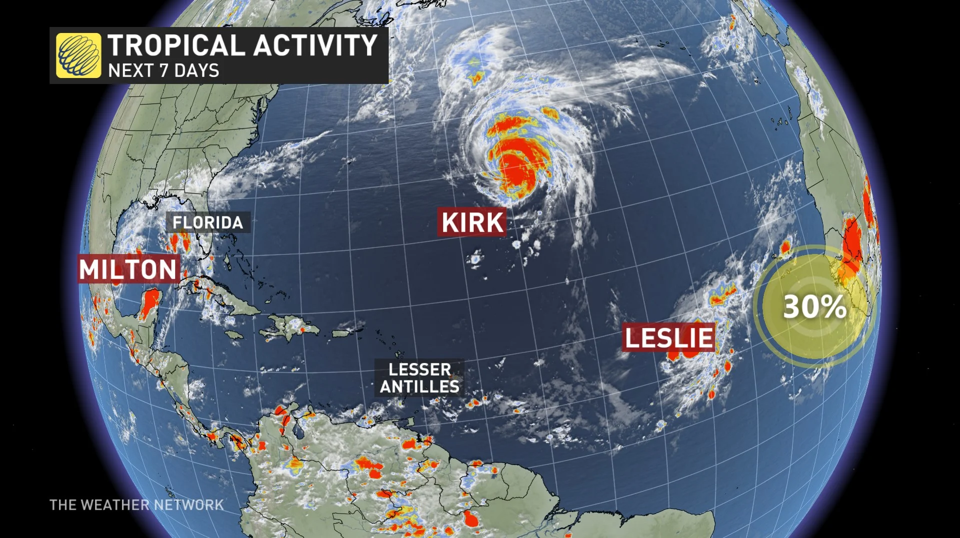
Milton is undergoing rapid strengthening, becoming a hurricane on Sunday, with further intensification that will likely see it reach major status on Monday.
DON’T MISS: Autumn can still produce intense hurricanes across the Atlantic
Alerts associated with Milton have been issued, with a tropical storm warning and watch now in place for parts of Mexico.
Anyone in Florida this week should take this storm seriously and closely monitor the latest forecasts and alerts from local officials.
Milton becomes hurricane and is still rapidly intensifying
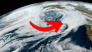
Milton developed on Saturday from a vigorous disturbance in the southwestern Gulf of Mexico. Favourable environmental conditions, paired with very warm waters, is allowing the system to rapidly intensify as it heads east toward Florida. A landfall along Florida's west coast is likely during the day on Wednesday.

The storm is going to take an unusual path. Only a few storms in recorded history have ever moved from the southwestern Gulf east toward Florida. This track will maximize the amount of warm water Milton traverses before reaching land.
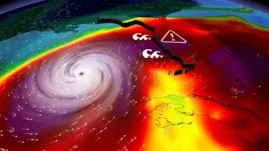
As a result, the U.S. National Hurricane Center (NHC) expects Milton to quickly grow into a major hurricane on Monday as it moves across the Gulf of Mexico. At the moment, Milton has maximum, sustained winds have increased to near 130 km/h, with higher gusts, making it a Category 1 hurricane.
“On the forecast track, Milton is forecast to move north of the Yucatan Peninsula and to move across the Gulf of Mexico and approach the west coast of the Florida Peninsula by midweek,” the NHC said early Sunday afternoon.

The precise landfall location is still uncertain right now. Milton’s powerful core could move ashore anywhere from Fort Myers in the south to the hard-hit Big Bend region to the north. As of Saturday, it’s most likely that the storm will make landfall somewhere near Tampa Bay, Sarasota, or Cape Coral.
It’s worth noting that the storm’s strength and fast forward speed would bring strong winds well inland across Florida. Depending on the track, this could bring dangerous winds into the Orlando metro area and portions of Florida’s east coast.
A dangerous situation for Florida
Widespread flooding rains will begin well ahead of Milton’s arrival this week. Most of the Florida Peninsula is in line for several days of very heavy rainfall that’ll culminate in the hurricane’s arrival on Wednesday.
MUST SEE: Why focusing on a hurricane’s category is downright dangerous

A surge of tropical moisture will collide with a stationary front parked over Florida to begin the week. This front will help wring out the excess moisture in the atmosphere, leading to a long period of heavy rains before Milton’s landfall.
This slug of pre-storm rainfall is somewhat similar to what we saw ahead of Hurricane Helene late last month. Many communities throughout Florida could see 125-200+ mm of rain during this event. Some localized areas could even see up to 300 mm.
"This rainfall brings the risk of locally considerable flash, urban, and areal flooding, along with widespread minor to moderate river flooding with major flooding possible," NHC warned in its latest statement.
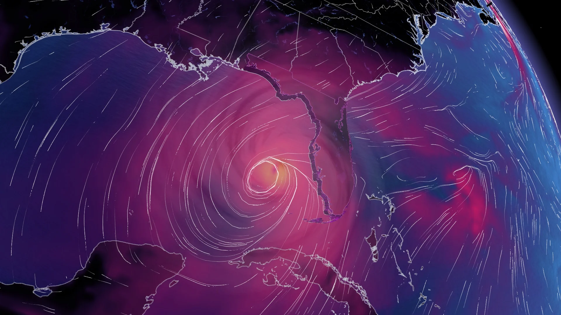
Powerful winds in the core of the hurricane will cause significant damage near the point of landfall. Damage to homes and businesses is likely, along with long-lasting power outages in the hardest-hit communities.
A life-threatening storm surge is likely where the hurricane makes landfall. Florida’s western coast is exceptionally vulnerable to storm surge flooding. Depending on the hurricane’s ultimate track, this could be a very dangerous situation for the Tampa Bay area.
As with any landfalling tropical system, tornadoes will also pose a threat to the Florida Peninsula as Milton makes landfall this week. Stay alert for tornado watches and warnings throughout the state. Tropical tornadoes can happen quickly with reduced tornado warning lead time.
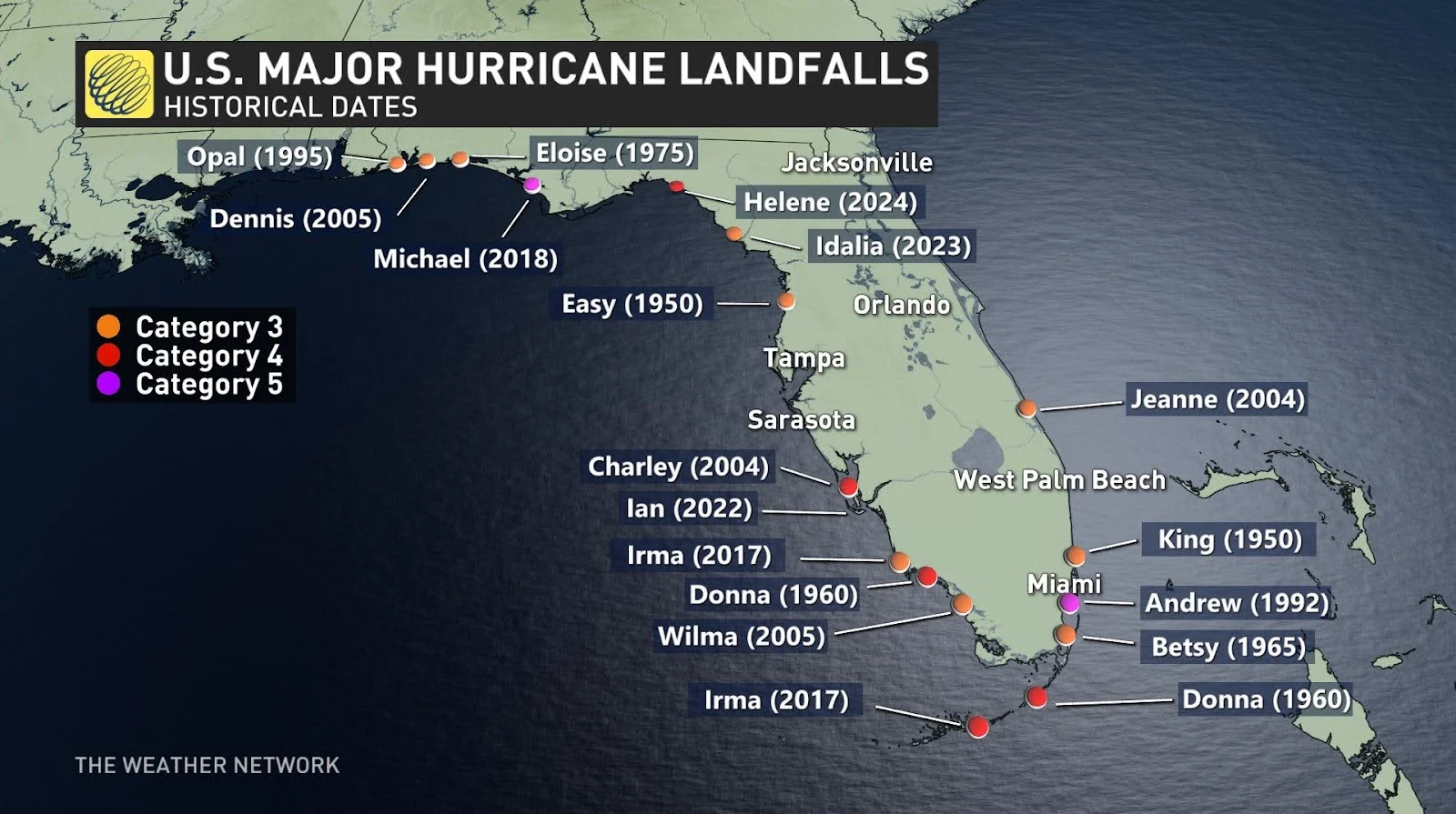
It's also worth noting that this is a rare situation overall. A major hurricane hasn't directly hit the Tampa Bay area in living memory. The last major hurricane to strike the region occurred back in 1921.
Hurricane season rolls ahead
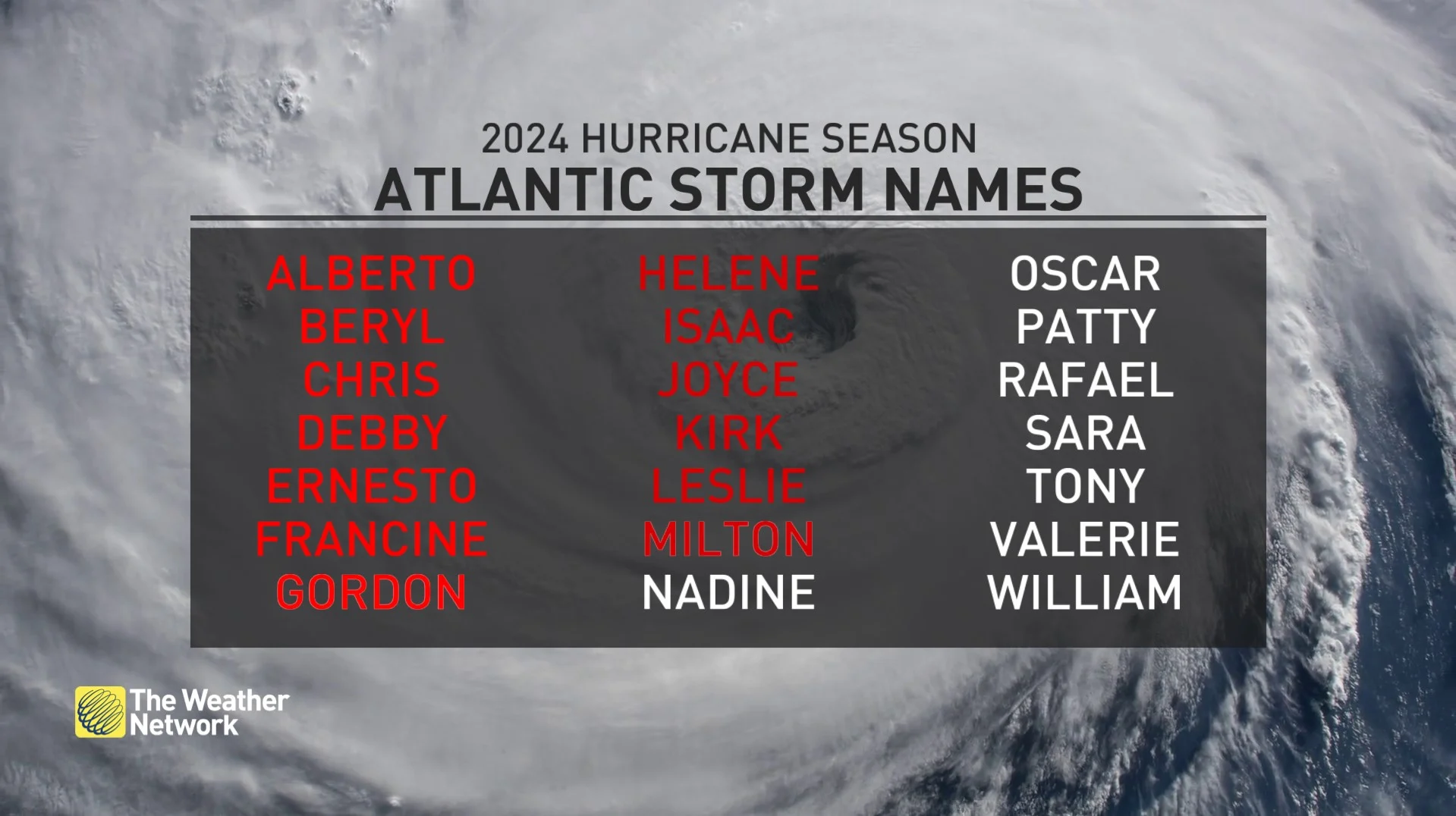
We’ve still got a long way to go before we’re through with this year’s hurricane season. Milton is this year’s 13th named storm—one shy of the seasonal average of 14 named storms.
Even though we’ve had a slower-than-expected hurricane season so far this year, it’s been a destructive year in terms of landfalls across the United States. If the forecasts pan out, Milton would be the fifth hurricane to make landfall along the U.S. Gulf Coast since early July.
Milton’s threat comes at a sensitive time for the southeastern United States. Residents across northern Florida continue to pick up the pieces from Hurricane Helene’s landfall just over one week ago. Helene struck near Perry, Fla., on Sept. 27 as a Category 4 hurricane, with maximum, sustained winds of 225 km/h.
Thumbnauk courtesy of NOAA.