Debby weakens to a tropical storm after Florida landfall as hurricane
Although Debby has been downgraded to a tropical storm after making landfall as a Category 1 hurricane Monday morning, it is still expected to cause major flooding over the southeastern United states during the next few days.
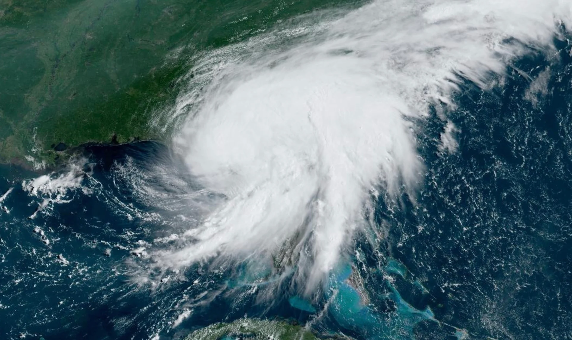
Debby made landfall in Florida Monday morning as a Category 1 hurricane, and is forecast to bring widespread, intense winds, torrential rains, coastal flooding, and tornadoes to the U.S. state through Monday.
Since making landfall, it has weakened back into a tropical storm. But the storm’s effects will linger long after landfall.
Stalling out after crossing the coastline, Debby will remain over the same areas for much of the week, bringing the risk for major flash flooding from Florida to North Carolina.
Keep up with all the latest news and information this season at The Weather Network’s hurricanes hub page.
Debby hits Florida as a hurricane, but is now a tropical storm once again
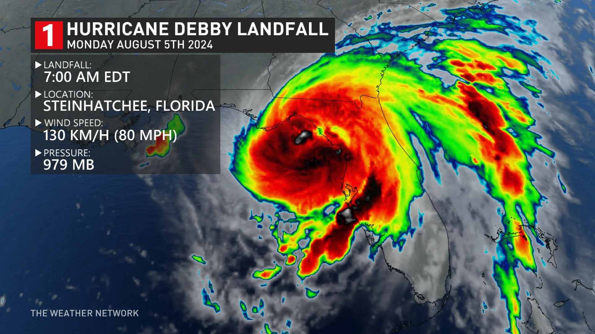
Air Force Reserve Hurricane Hunter aircraft observations and Doppler radar images from Tallahassee confirmed the centre of Hurricane Debby made landfall around 7 a.m. EDT near Steinhatchee, Fla., in the Florida Big Bend.
Data from the Hurricane Hunters indicate that the maximum winds at landfall were estimated to be around 130 km/h –– a Category 1 storm.
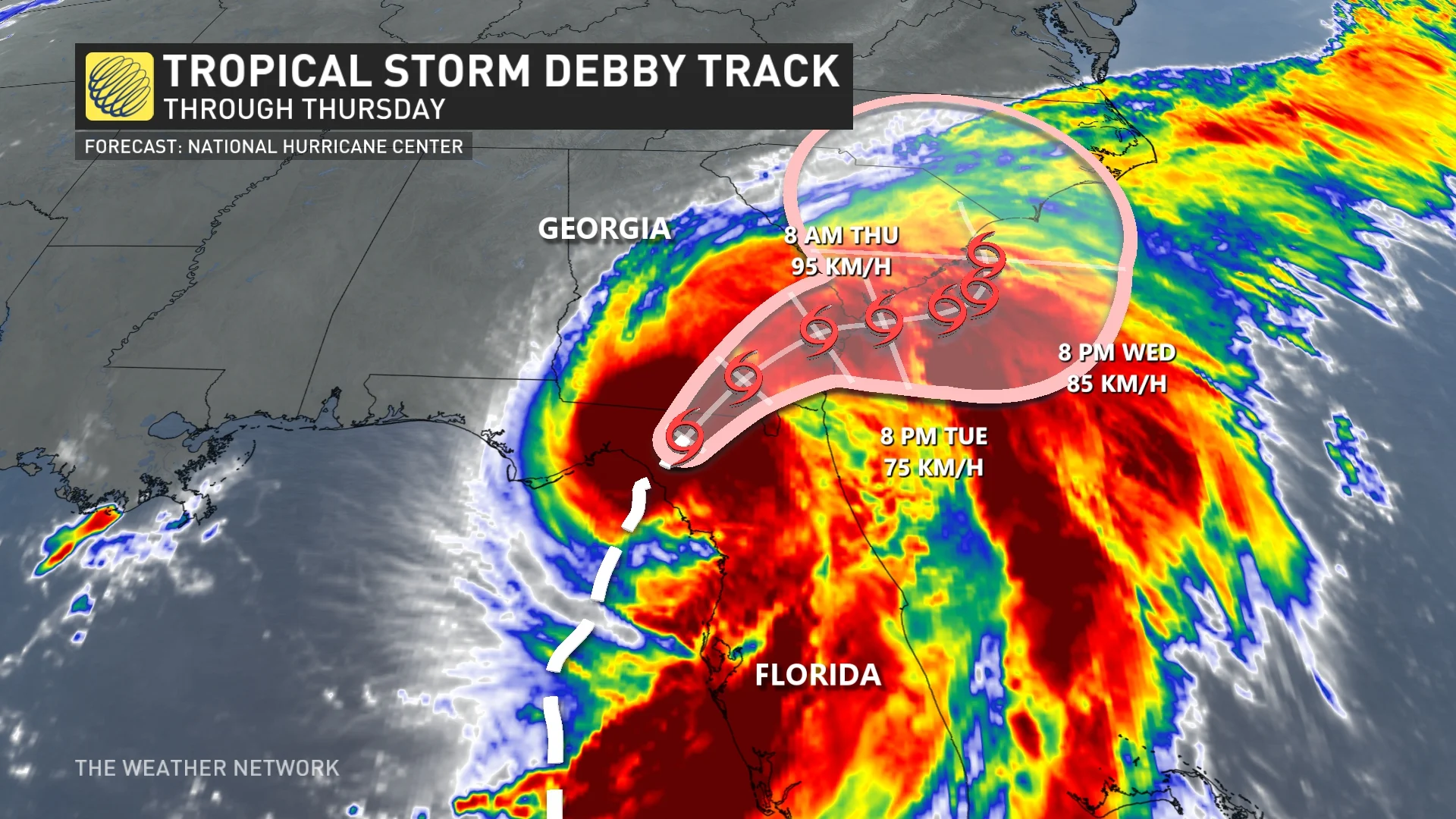
They have since weakened to near 110 km/h, with higher gusts, putting Debby into tropical storm status once again. Additional weakening is expected during the next 48 hours.
Widespread tropical storm warnings cover a good part of Florida that remains in Debby's path.
While downed trees and power outages are likely from Debby’s strong winds, flash flooding from heavy rainfall is far and away the greatest threat with this storm.
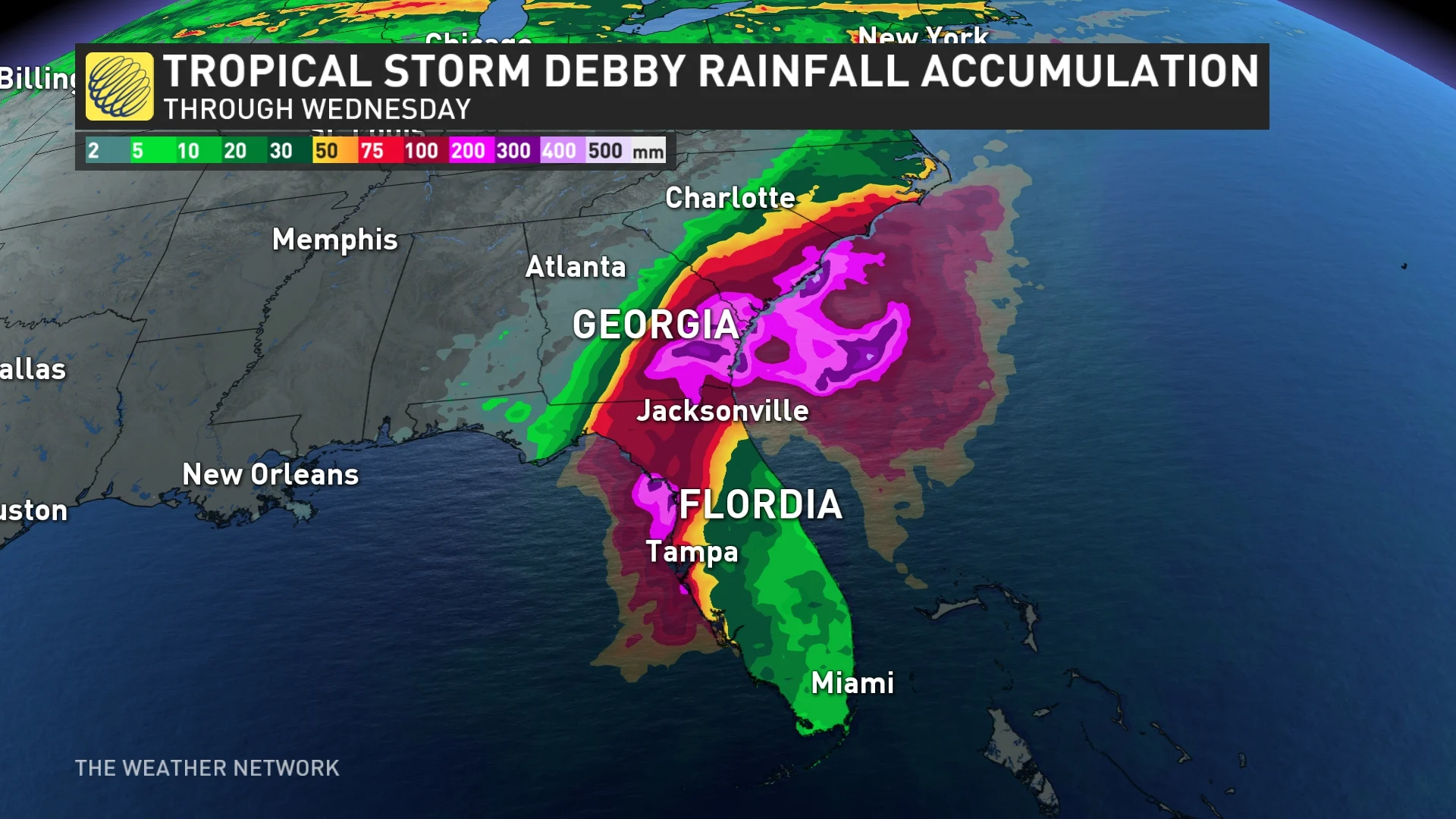
Debby is expected to produce rainfall totals of 150 mm to 300 mm, with maximum amounts of 450 mm, across portions of northern Florida through Friday morning. The rainfall will likely result in areas of considerable flash and urban flooding, with significant river flooding expected.
Additionally, folks throughout central and northern Florida, as well as southeastern Georgia, can expect a risk for tornadoes through Monday, before the threat pushes into parts of South Carolina Monday night.
Folks can also expect rough surf, and rip currents as a result of this disturbance.
Storm to stall with an extreme flood threat across the southeast
Debby will enter a complex environment that’ll make its future track and intensity a bit more uncertain. Two strong ridges of high pressure, one over the western Atlantic and another over the southern U.S., will each push and pull on the storm.
As a result of that setup, the storm is likely to stall over or near Georgia and the Carolinas, drenching the region with a prolonged rainfall event. This is likely to cause major flooding issues throughout the region.
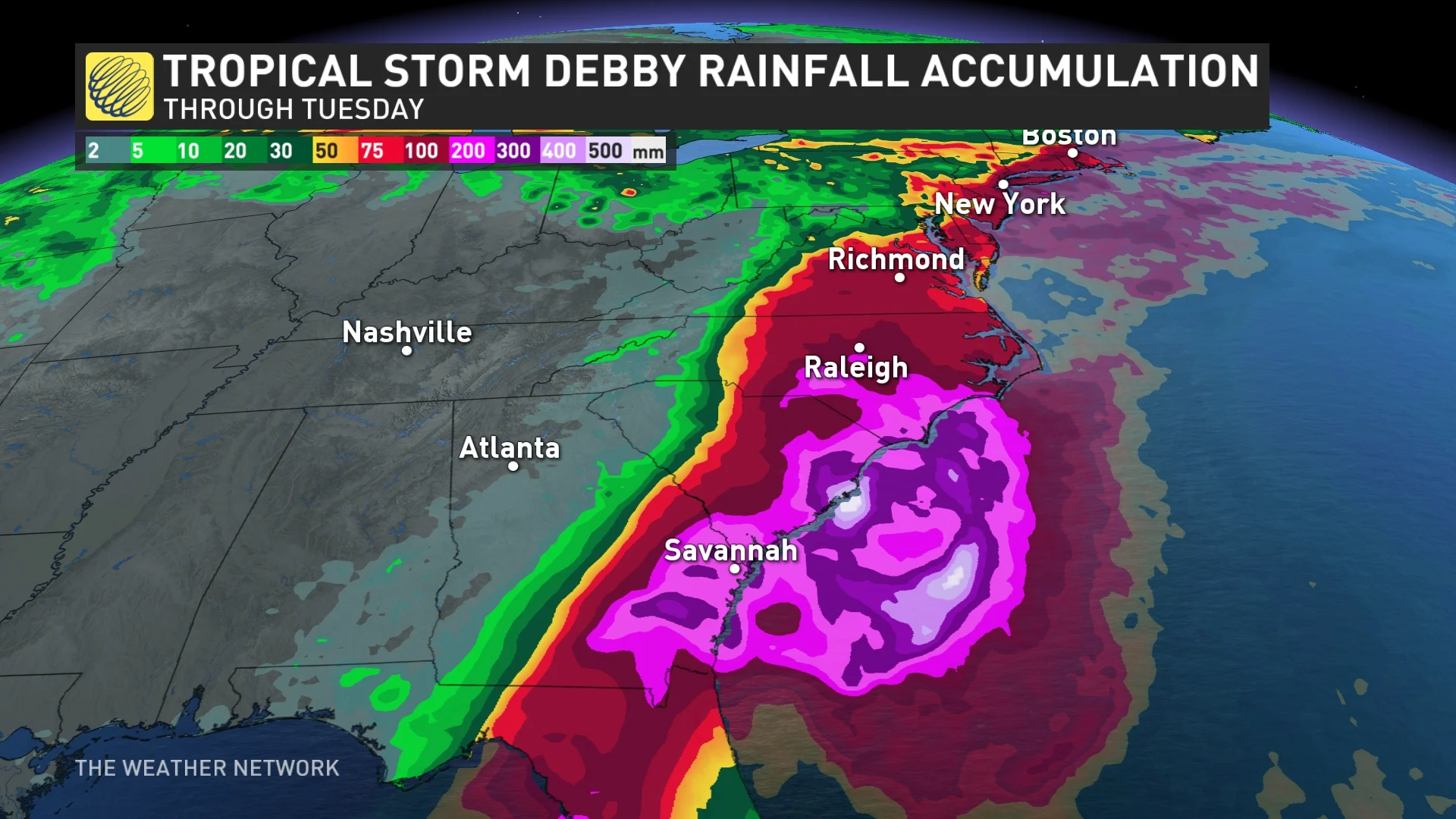
Across portions of southeast Georgia and South Carolina, 250 mm to 500 mm of rainfall is expected, with local amounts potentially reaching 760 mm.
"This potentially historic rainfall may result in areas of catastrophic flooding," the NHC warns.
Anyone visiting popular vacation destinations along the Atlantic coast, including the cities of Savannah, Charleston, Myrtle Beach, and Wilmington, should keep a very close eye on this storm and prepare to act if watches or warnings are issued for the region.
It’s still too soon to say what, if any, impacts this system could have on Atlantic Canada late this week. Stay tuned and keep checking back for details.
Header image courtesy of NOAA.