Cross-country storm to put a big spin on Canada’s forecast
A budding storm will trek across the country through next week, bringing foul weather along its route
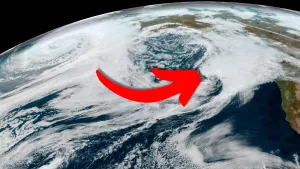
A cross-country storm is in the works that’ll bring a wide swath of unsettled weather from British Columbia to the East Coast and just about everyone in between.
Most of Canada will feel this storm’s influence at some point over the next week.
DON'T MISS: Look up! Auroras may shine across Canada through Friday night
Rain incoming for B.C. and the Prairies
A strong centre of low pressure west of Alaska will help slingshot a smaller low-pressure system across Canada over the next seven days, bringing just about every corner of the country some active weather through next week.
The storm starts its journey in British Columbia, where it’ll bring rain to coastal areas and snowflakes to the highway passes through Friday. The heaviest precipitation is likely across higher elevations across the Central Coast, though some measurable rain is likely across the Lower Mainland for the end of the week.

Our system will lose some of its moisture as it traverses the Rockies overnight Friday, bringing steady rain to northern Alberta while a chance for showers covers the south. The low will push into Saskatchewan with some light rain for our Saturday.
Conditions will improve for Saskatchewan through the overnight hours as rain accompanies the low into Manitoba. We’ll see the weather improve from west to east to end the weekend as our storm embarks on the second half of its Canadian journey.
System ends the weekend in Ontario, slows in Quebec
Ontario is the next stop on this cross-country trip. The low-pressure system will mosey into northern Ontario on Sunday, tapping into some Gulf moisture along the way.

This enhanced feed of moisture from the south will fuel a renewed batch of rain across northern Ontario. A cold front extending off the system will push rain into southern Ontario through the day Sunday. Cooler temperatures will also filter into the region behind that front.
RELATED: Spectacular fall weekend, but with a catch in southern Ontario

Things will also get a little messy Sunday as the system encounters an atmospheric traffic jam over the eastern half of the country. A centre of high pressure over Labrador, combined with a trough over Atlantic Canada, will force the system to slow to a crawl over Hudson Bay.
Not only will this slowdown force rain to linger in Quebec through Sunday night and well into the day Monday, but it could also bring a chance for snow to northern Ontario as we head into Monday.
The last leg of this low’s Canadian adventure will take place early next week as those blocking features clear out of the system’s way. The low will creep into the Maritimes for our Tuesday and move into Newfoundland by Wednesday. Another centre of high pressure over Greenland will force this system to sit over Atlantic Canada for another couple of days.