SUMMER 2021: A look ahead at Canada's most anticipated season
The Weather Network's official 2021 Summer Forecast reveals what Canada can expect for the heart of the summer season.
Summer is the most anticipated season of the year for many Canadians, likely more so this year than ever. With summer now upon us, will the weather be ideal for getting outside to enjoy your favourite summer activities? To help answer this question, let’s take a look at The Weather Network’s summer forecast for the rest of June, July and August.
Our summer forecast features great weather for enjoying the beach and backyard barbecues, as most of Canada will see near-normal or above-normal temperatures, and more than the typical number of sunny days.
However, there is a downside for areas where we expect a hot and dry summer. Drought conditions are a major concern for agricultural regions across much of Western Canada, along with a heightened risk for wildfires and poor air quality later in the season. On the other side of the country, a very warm and occasionally stormy summer is expected along with a very active hurricane season, and an increased risk for tropical impacts to Atlantic Canada.
Here is a closer look at the temperature pattern that we expect to dominate across Canada this summer.
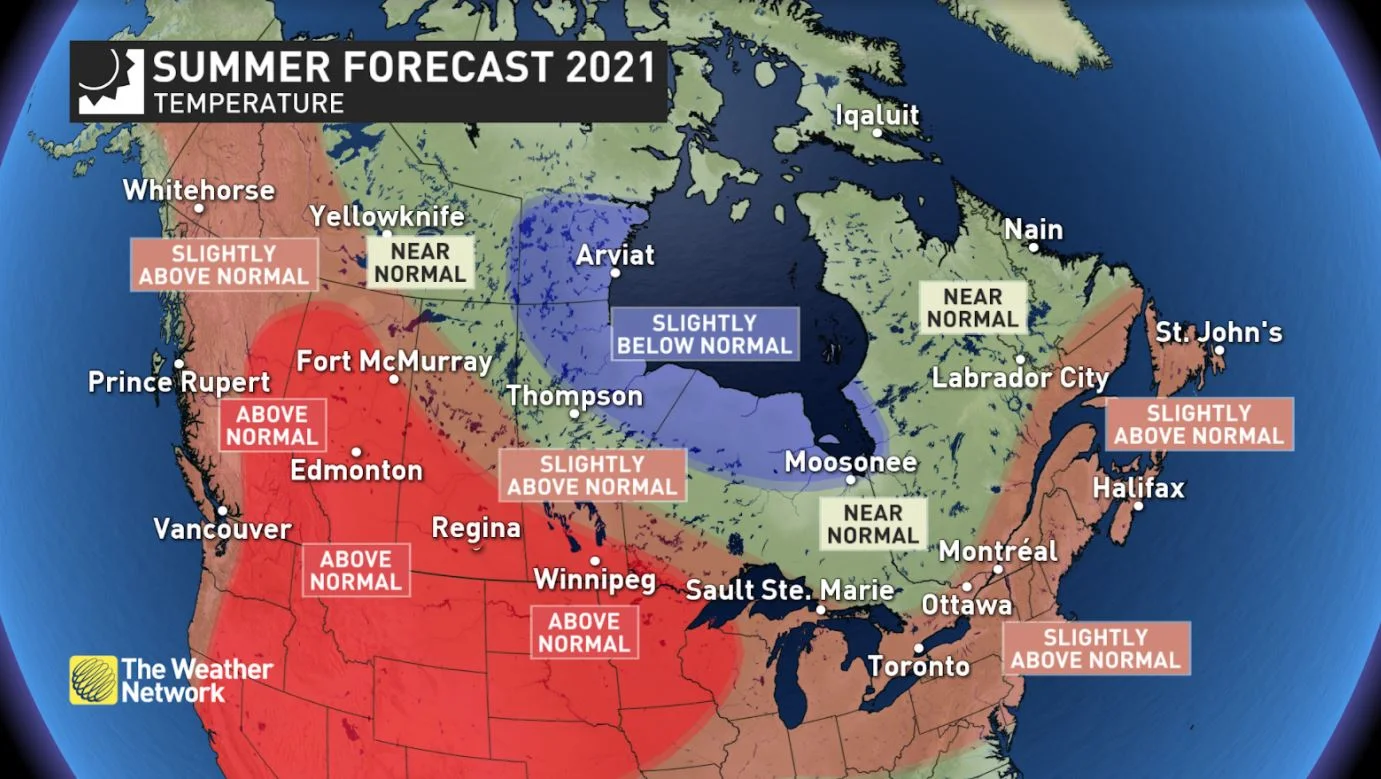
The hottest weather this summer (relative to normal) is expected across the southern Prairies. The area of greatest uncertainty is across Ontario, where periods of cooler weather will break up the heat at times. However, for southern Ontario we think that we will see enough hot weather to tip the final numbers to the warm side of normal. Across northern Ontario, the back-and-forth swings in temperatures should come close to offsetting each other and result in near normal temperatures.
Here is a look at our national precipitation forecast for the summer season.
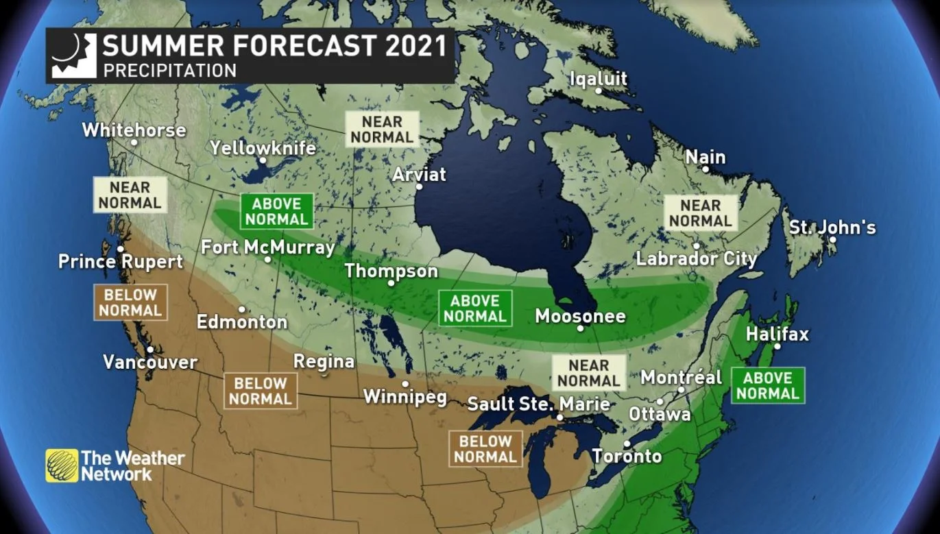
While late May and the first half of June finally brought some relief from the exceptionally dry conditions across the southern Prairies, we are concerned that this region will return to a very dry pattern as we head into the heart of summer, with the potential for major impacts on agriculture. Dry conditions across southern and central B.C., and also across parts of northern Ontario would also bring a heightened risk for wildfires.
Visit our Complete Guide to Summer 2021 for tips to plan for the season ahead and much more!
Further to the north, we expect a stormy pattern at times across parts of the central and northern Prairie provinces, then stretching east to central Quebec. A wetter pattern is also expected near the East Coast of the United States and that should extend northeast across the Maritime provinces with a heightened risk to be impacted by tropical storms and hurricanes.
Southern Ontario and southern Quebec could tip either way as they are sandwiched between the anticipated dry pattern to the west, and a wetter and stormier pattern to the south and east. However, we think that the most likely scenario for this region is that we see extended periods of dry weather, which will get broken up by strong storms at times and a few moisture-laden systems.
Below is a more detailed look at the conditions that we expect across Canada this summer:
BRITISH COLUMBIA
A hot and dry summer is expected across the southern and central Interior of the province, and a very warm and dry summer is expected for the southern and central coast, including Vancouver and Victoria. Northern parts of B.C. will also see above-normal temperatures, but near normal rainfall is expected.
An abundance of warm or hot sunny days will be ideal for those who are looking forward to spending time on or by the water. However, the combination of above-normal temperatures and below-normal rainfall will bring a heightened risk for wildfires and poor air quality, especially during the second half of the season.
WATCH BELOW: ALL EYES ON PRECIPITATION HEADING INTO DRY SEASON
ALBERTA
A hot and dry summer is expected across most of the province, especially across southern and central parts of the province (including Calgary and Edmonton), where we are concerned about a return to drought conditions during July and August with a risk for major impacts to agriculture. We are also concerned about the heightened risk for wildfires and the associated periods of poor air quality for areas that are downwind of the fires.
To the north of the region that sees a hot and dry summer, we expect an active storm track with frequent showers and thunderstorms. However, there is still uncertainty as to exactly where that will set up and it is possible that we will see the active storm track set up further to the south from our current forecast.
WATCH BELOW: WILL A WARM TREND HEIGHTEN FIRE AND DROUGHT RISK?
SASKATCHEWAN AND MANITOBA
A hot and dry summer is expected across southern and central Saskatchewan, and southern Manitoba. This area finally saw some much-needed rain during late May and the first few weeks of June. However, a very dry pattern is expected to resume for the heart of summer with the potential for major impacts to agriculture.
Further to the north, an active storm track is expected this summer. The exact storm track is still uncertain, but at this point it looks like it will be too far north to consistently bring beneficial rain to agricultural areas. However, it is possible that the storm track will shift further to the south at times.
ONTARIO
An abundance of sunshine with near-normal or slightly above-normal temperatures are expected across most of the province.
The warmest weather relative to normal is expected across southern and eastern Ontario, including Toronto and Ottawa, and also for areas near and west of Lake Superior. Periods of cooler weather will break up the heat at times, but there should be enough hot weather to tip the final numbers to the warm side of normal.
For most of northern Ontario, the back-and-forth swings in temperatures should come close to offsetting each other and result in near normal temperatures. However, a cooler and wetter summer is expected near Hudson Bay and James Bay.
Drought conditions across the southern Prairies are expected to extend east into parts of northern Ontario, including areas around Lake Superior, with a heightened risk for wildfires. A more active storm track is also expected across the far north.
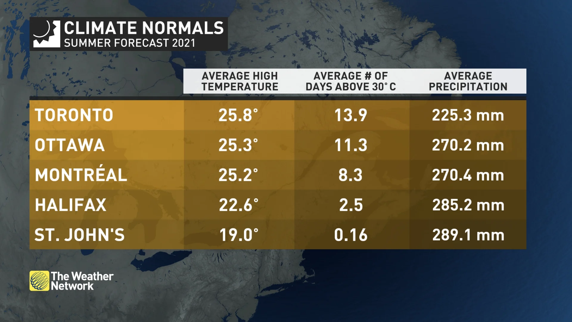
For southern Ontario, we are concerned that we will continue to see extended periods of very dry weather. However, strong thunderstorms at times and a few moisture-laden systems will bring the potential for near-normal rainfall totals despite fewer rainy days than normal.
WATCH BELOW: WILL DROUGHT CONDITIONS CONTINUE THROUGH SUMMER?
QUEBEC
An abundance of sunshine and above seasonal temperatures are expected to dominate this summer across southern and eastern Quebec, including Montreal and Quebec City, with occasional breaks from the heat at times. Extended periods of dry weather are likely, but like last summer, a few moisture-laden systems should bring the final totals to near normal. A more active storm track is expected to the north across central Quebec.
WATCH BELOW: IF YOU LIKE THE HEAT THIS COULD BE THE YEAR FOR YOU
THE MARITIMES
A very warm and humid summer is expected across this region. The higher humidity will have a significant impact on overnight temperatures, which means fewer chilly nights for camping, but also some difficult sleeping weather at times.
While we expect the final rainfall totals to be above normal for much of the region, we do not expect more rainy days than normal. We still expect periods of dry weather and the typical number of days with sunshine.
However, ocean water temperatures continue to run several degrees warmer than normal, so any storm systems that tap into Atlantic moisture will have a higher potential to bring excessive rain at times. Additionally, a very active hurricane season is expected, with a higher risk for the region to be impacted by the remnants of tropical systems.
WATCH BELOW: ACTIVE ATLANTIC HURRICANE SEASON FORECAST THIS YEAR
NEWFOUNDLAND AND LABRADOR
A very warm and humid summer is expected across Newfoundland, and near-normal temperatures are expected across Labrador. Near-normal rainfall totals are expected across the region. However, an active hurricane season is expected, so if the remnants of a tropical system track across the region, we could see localized totals on the wet side of normal.
WATCH BELOW: WILL IT BE A HOT BEACH SUMMER OR A WASHOUT?
NORTHERN CANADA
A warmer than normal summer is expected for the Yukon and across western parts of the Northwest Territories. Near-normal temperatures are expected across the eastern half of the N.W.T. and most of Nunavut. Below-normal temperatures are expected near the western shoreline of Hudson Bay.


