Why Florida’s west coast is so vulnerable to storm surge flooding

A storm hitting Florida’s west coast could push an unsurvivable storm surge into densely populated areas
Florida is more susceptible to hurricanes than just about any other spot in North America. While any raging storm aiming for the Sunshine State is bad news, the state’s western shores are exceptionally vulnerable to dangerous flooding when a hurricane makes landfall.
Here’s a look at the natural features that make Florida’s west coast a sitting duck in the path of looming hurricanes.
DON'T MISS: What is a hurricane storm surge, and why is it so dangerous?
Storm surge is a deadly hazard in hurricanes
Destructive winds and flooding rains are a significant hazard in any storm approaching the coast. But it’s storm surge that often leaves the most devastation in a powerful hurricane’s wake.

Damage in Galveston, Texas, from Hurricane Ike’s storm surge in 2008. (NOAA/NWS)
Storm surge flooding is seawater pushed inland by the force of a storm’s intense and persistent winds. This flooding occurs quickly as a storm approaches landfall, potentially inundating coastal communities in under an hour.
A storm surge can reach more than 6 metres above ground level in the strongest hurricanes. This kind of surge is unsurvivable for folks in harm’s way. The deepest surge can completely inundate or even wash away a well-built home.
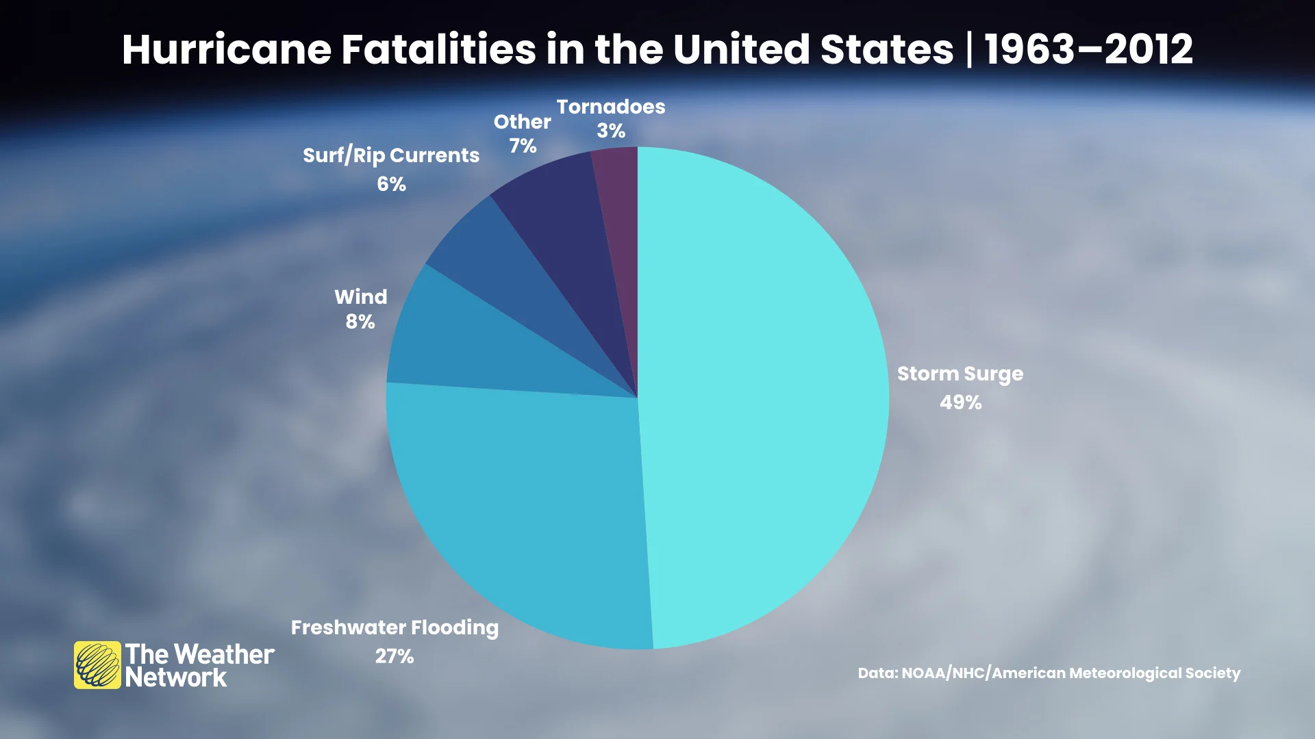
A 2023 study found that nearly half of all fatalities in landfalling hurricanes in the U.S. between 1963 and 2012 were the result of storm surge flooding. This includes hurricanes like Camille in 1969 and Katrina in 2005.
Geography makes coastal flooding worse
Multiple factors dictate the severity of storm surge flooding. The size, intensity, and duration of the storm all play a role, as do geographical considerations like the shape of the coastline and the type of terrain near the coast.
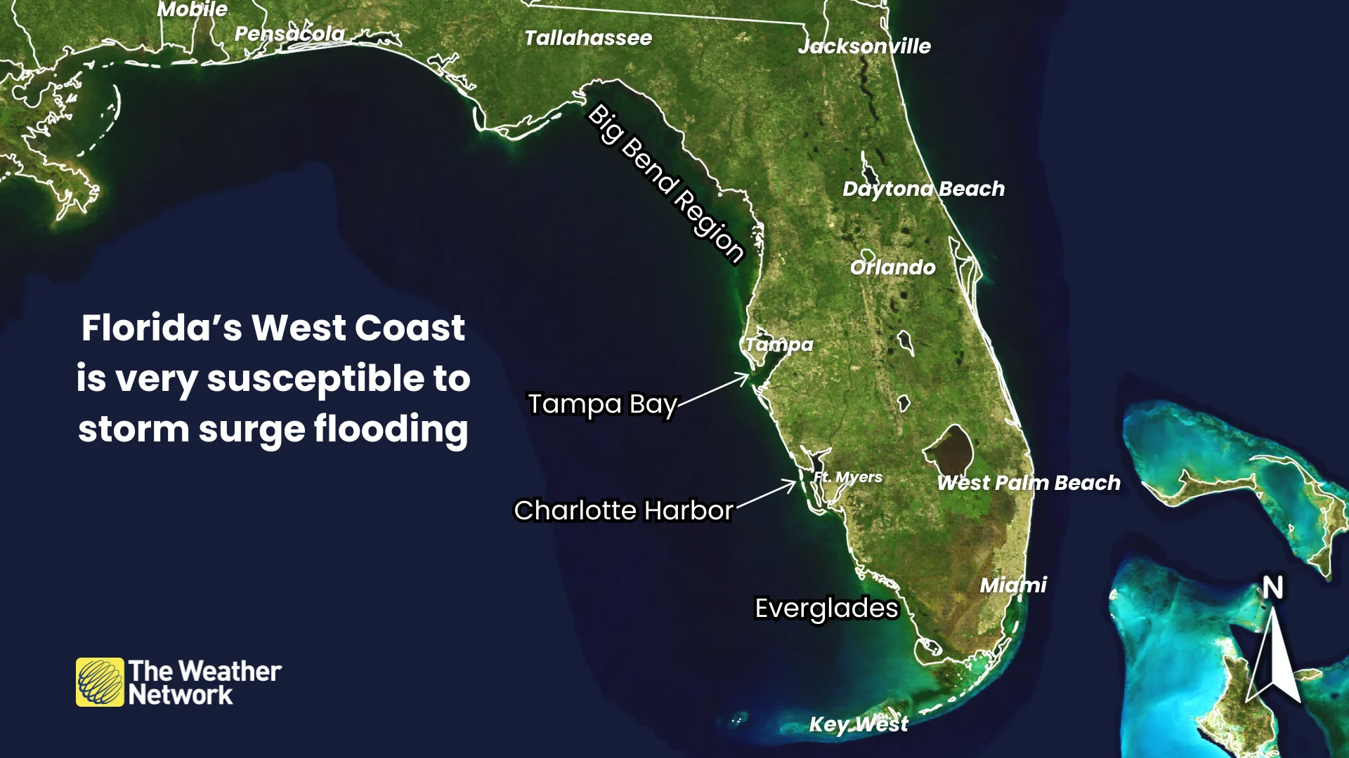
Florida’s western coast is a mix of swampy terrain, bays, and inlets that can allow a tremendous storm surge to rush ashore when a storm makes landfall.
Tampa Bay is extremely vulnerable due to its location, shape, and the region’s high population density.
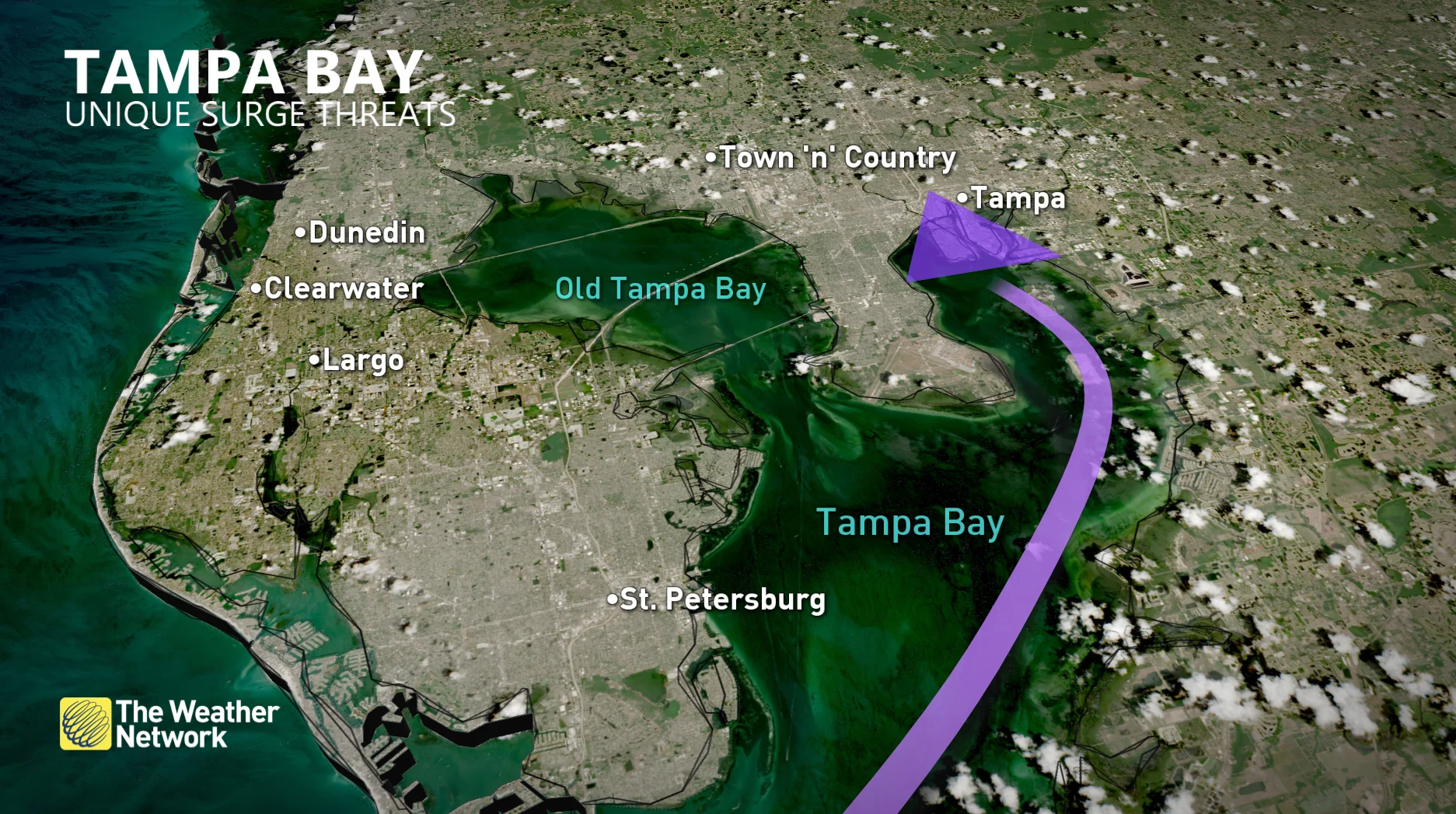
A direct strike on Tampa Bay could funnel an immense surge directly into the bay, forcing several metres of water to inundate Tampa’s downtown core as well as densely populated neighbourhoods throughout the region. Thousands of homes would be uninhabitable in the worst-case scenario.
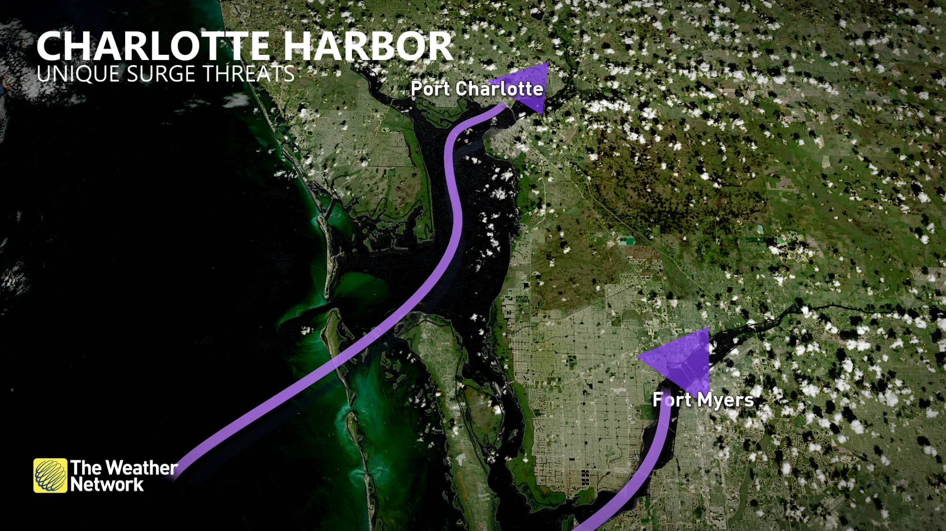
Charlotte Harbor, which sits a little over 100 km to the south of Tampa Bay, boasts a similar shape that’s capable of funneling and amplifying a storm surge. Cape Coral and Fort Myers are also exposed to storm surge along the Caloosahatchee River.
Vast stretches of Florida’s western coast consist of low-lying, swampy terrain that offers little to no resistance against a hurricane’s storm surge flooding.
The famous swamps of the Everglades make up much of Florida’s southwestern shores, while the Big Bend region north of Tampa Bay is one of the region's biggest marshlands.
Storms here have been few and far between
The last hurricane to directly hit Tampa Bay occurred in 1946, while the last major hurricane to hit the region struck all the way back in 1921.
Why so long? It’s through a mixture of luck and climatology that few hurricanes directly threaten Florida’s west coast and the Tampa area in particular.
Most of the storms that form in the Gulf of Mexico or enter the Gulf from the south tend to head north, sparing western Florida and instead aiming for the state’s Panhandle or regions like Louisiana.
No stretch of coast is immune from hurricanes, though, and Florida’s western coast is no exception.
MUST SEE: Why focusing on a hurricane’s category is downright dangerous

Hurricane Helene approaches western Florida on September 26, 2024. (CIRA/NOAA)
Hurricane Helene struck Florida’s Big Bend region in September 2024 with an estimated storm surge greater than 15 feet (4.5 metres) above ground level in places like Steinhatchee and Horseshoe Beach.
That storm’s outer fringes pushed into St. Petersburg, where the Gulf of Mexico rose more than half a metre higher than the city's ever measured before.
Hurricane Charley made a direct landfall in Punta Gorda as a hulking Category 4 storm back in August 2004. The storm’s worst winds narrowly missed Charlotte Harbor, pushing a 1-2 metre storm surge into communities just south, including Sanibel Island and the city of Fort Myers.
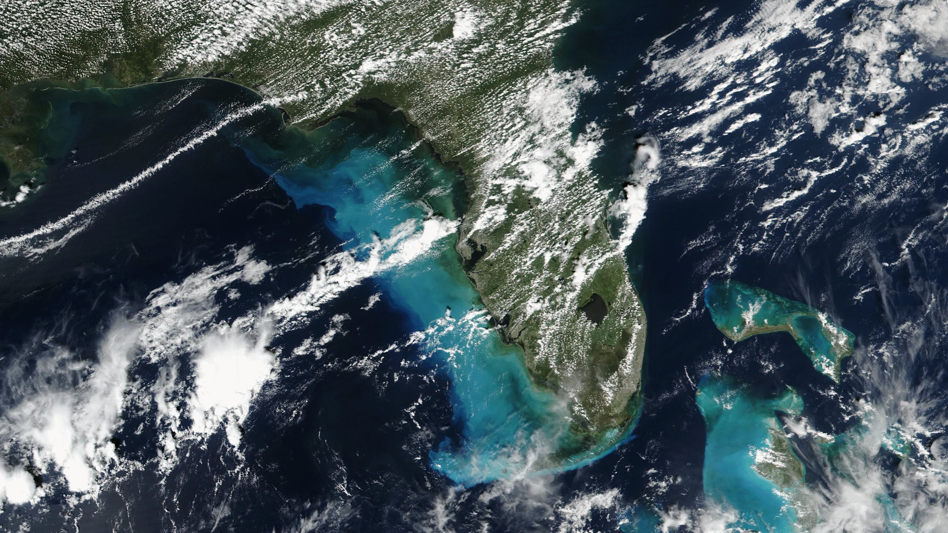
Header image courtesy of NASA Worldview.