How a giant blockade over Canada will shatter October heat records

Temperatures will soar into record territory across Ontario as we begin October, and this bout of unusual heat is the result of an upper-level traffic jam
It takes a remarkable upheaval in the atmosphere to break weather records that have stood for generations.
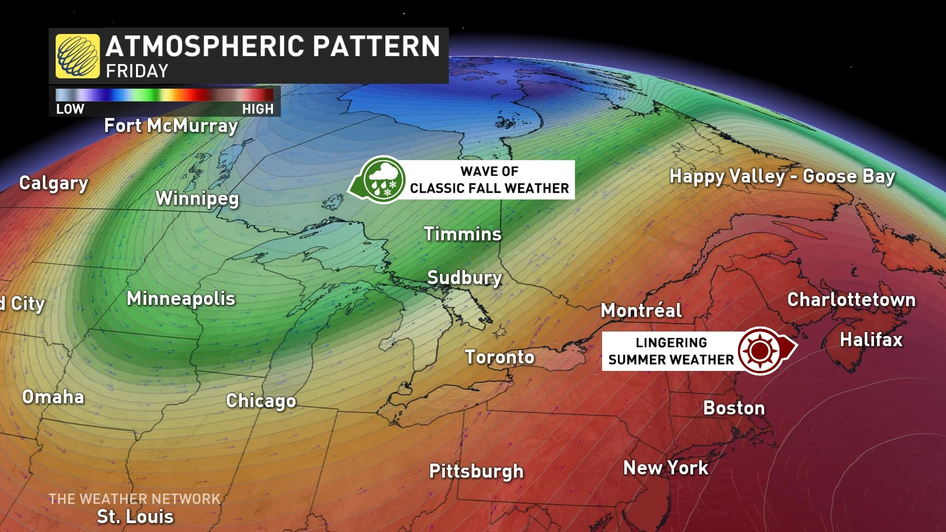
The upper-level winds over Canada for the first week of October will twist and contort in spectacular fashion, creating what amounts to a blockade that’ll bring mid-summer weather to some communities even as we’re entering the heart of fall.
Visit our Complete Guide to Fall 2023 for an in-depth look at the Fall Forecast, tips to plan for it and much more!
Many communities across Ontario could see their warmest October days ever recorded this week as a large ridge of high pressure builds in the atmosphere high over the Great Lakes region.

This ridge is part of an active jet stream that’s swooping and arching its way across the country to begin the month. These troughs and ridges tend to move along in a hurry when the jet stream is this imbalanced, but some patterns force the flow to grind to a halt.
One such pattern is an Omega block.
Named for its uncanny resemblance to the Greek letter Omega, this upper-level blocking pattern features a large ridge of high pressure bookended on either side by troughs.
YOUR OCTOBER OUTLOOK: October attempts to defy El Niño in Canada with atypical fall warmth
This sequence is a little bit like kinking a garden hose to make the water stop—but, instead of stopping up the winds, it just stops the jet stream from progressing along.
While most troughs and ridges come and go over the course of a day, an Omega block can force these features to stick around for days on end.
Lifting air rising ahead of a trough often brings unsettled conditions on either end of an Omega block—as we saw last week with the historic rains that washed through New York City.
Communities caught beneath the upper-level ridge, though, tend to see calm and unusually warm conditions for the duration of the pattern.
MUST SEE: From upper 20s to snow: Huge pattern flip looms for Central Canada
A long-duration Omega block can be bad news during the warmer months, potentially fostering a dangerous spell of excessive heat for the duration.
But during the month of October, when the concept of ‘seasonal’ changes pretty quickly, daytime temperatures coming in 10-20 degrees above seasonal is both extremely unusual and eminently bearable.
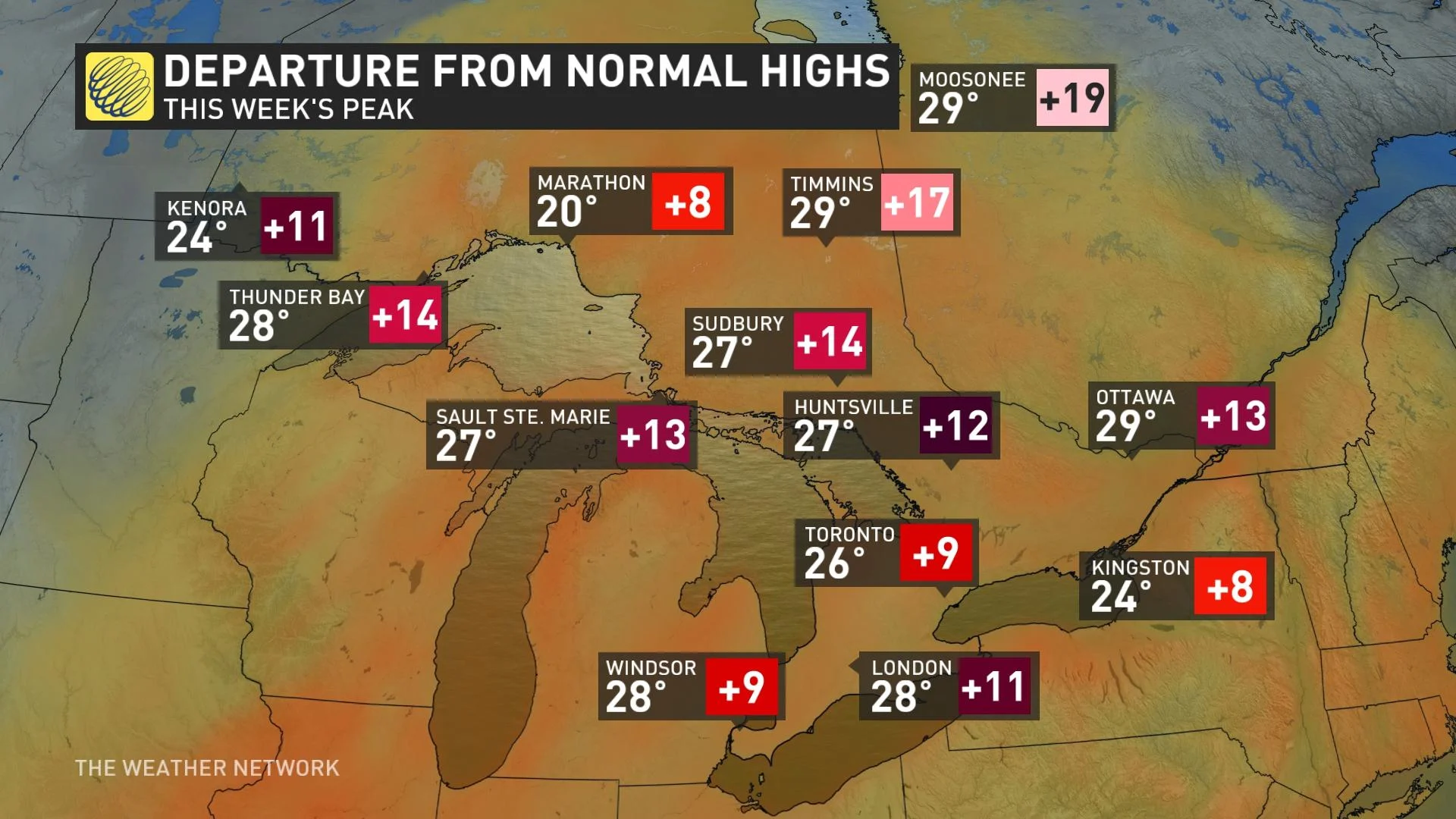
Forecasters expect daytime highs to climb into the upper 20s during the upcoming week for a huge swath of Ontario from Toronto to Moosonee, the latter of which stands a chance to break its all-time monthly temperature for the second month in a row.
It takes an equally potent shift in the upper-level pattern to dislodge an Omega block and send the disruption moving along its way downstream.
A powerful trough dipping south out of Northern Canada will be the key to breaking this latest blocking pattern over Ontario. The trough will bring much more seasonable air with it, setting up a temperature drop of 15-20+ degrees by next weekend throughout much of the province, and even a chance for snow in spots.